
 High based were the order of the day given the high temperatures and large dew point deficit in Sydney. Storms began to develop after 2pm with the first showing signs of severity near Richmond. Hail was reported from this cell by Nick Moir. From here, numerous cells began to develop across the mountains and further south. It seems that Sydney was the extent of the main embedded cells. More isolated cells were observed in the Wollemi and east of the Putty Road. The slow movement of the cells resulted in warnings for heavy rainfall and possible flash flooding. It was inevitable that the higher bases led to some localised downbursts reported from Penrith, Windsor and Schofields.
Good to see some people out and about – storms produced some much needed heavy rain despite the disappointing structures overall. Did somebody suggest sounding indicative of 14km heights? I don't think the storms were able to tap into the moisture to develop explosively today.
I was at Windsor and watched, filmed and photographed the entire storm event. As soon as I have an opportunity to work on photos and film, I will upload them. One particular storm was interesting. It developed close to me and passed overhead. As it did heavy rain fell which became heavier. Then it became windy with ESE winds blowing. That wind then swung to the east then north east as the storm passed over. The wind and rain was not cold.
I was amazed that near the southern portion of that storm, gale force winds struck the area and I observed leaves, small branches, bark and ocassional larger branch being torn from trees. I thought, am I inside a microburst? These winds caused the heavy rainfall to fall at an angle to the ground. I had to put my big camera away inside my camera bag due to the rainspray and to protect it from being water damaged. Following the storm, I heard sirens from emergency services, no less than 2 fire trucks and other emergency services attending an incident close by. I am not sure whether it was a lightning strike on power lines or fallen trees.
I did not observe hail where I was at Macquarie Park Windsor but there was some intense rain. I have looked at the weather stations for the area to find out the strength of the wind. The nearest one is Richmond Air Force Base which recorded a peak wind gust of 65 km/h from the ESE direction at 4.44 pm.
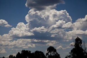
I managed to photograph a number of storm cells, including rain shafts, possible microbursts and cloud towers. Despite the storms being high based, they did produce some heavy rain showers.
Yeah, sounding indicative of around 13 km heights, wind shear wasn't that great.
This is the horse shoe shaped base of the cell west of Penrith that dropped a strong down-burst that knocked out our power for nearly 2 hours.
nice and rippled!
Cell to the south with pseudo wall cloud
Western cell getting closer
Southern cell with scud and pseudo funnel
Nice! Shame they could not tap into the surface moisture.
Jeff Brislane, was there much damage in your area from the microburst?
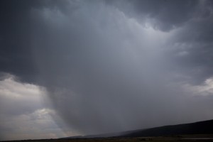
My first photo is taken from Bella Vista looking west. This is one of the first storms and the rain shaft and downburst / possible microburst can be seen. As I was taking these, I could see cloud to ground lightning but my aim at this stage was not to get the lightning but simply to take photos of cloud structure and the rainshafts. Following this, I drove out to Windsor passing underneath this. There was no wind at the time but some heavy rain and very large raindrops.
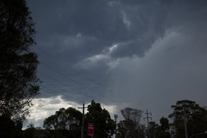
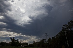
Upon my arrival at Windsor, I went to Macquarie Park where I was able to view new storms develop close by. Cloud bases were high. This is looking north west. There was a second storm cell to the south towards Penrith. The earlier storm was weakening. Ocassional cloud to ground lightning was observed.
Then this shortly after.
The main storm I experienced developed rapidly and close by. This is looking south west and was to be the storm that produced the heavy rain and downburst with significant wind. This is the only opportunity I had to view the cloud towers prior to the storm closing in. This storm certainly produced the rainfall but no hail event.
I had to put my big camera away as the storm passed over me. Using my smaller camera, I managed to take a few photos of what it was like inside the core. Heavy rain. I am focussing down to show the heavy rain while keeping the camera lens dry and free of rain spray. Gale force winds struck the area making it very hard to get any images. At one stage, I was taking these while holding my camera bags and camera gear to prevent water damage. At least I managed to get something and all the time, I was sheltering under a BBQ picnic shelter.
I have been working on the lightning photos. There was a third storm that passed just to the east of me. As there was no rainfall, I took advantage of this and took some images of lightning strikes. I am facing east.
Then this.
The storm became lightning active for a short period of time.
I wonder what could have been if we had more ‘surface based’ storms!
Nice lightning bolts. I can’t help but note the lightning in front of the tree – is that what you saw Harley?
It has been some time since I have heard the term pseudo being used. You may wish to explain what it means Jeff given it is not in the glossary on this website.
Jimmy. I shifted my camera and tripod under a picnic table / BBQ shelter due to the threat of lightning strikes from another storm behind me. As it was, there was one significant cloud to ground lightning strike with a substantial thunderclap. I did not capture that lightning strike. I am outside the car but I made sure I had a secure shelter available. I am fully underneath a picnic / BBQ shelter with solid roof.
My camera and tripod is between the BBQ grill and the picnic table and well under cover.
What made this more difficult is that the base of the next storm cell was overhead. It was too dangerous for me to be outside the confines of that picnic shelter. There were two storm cells and I decided to use two cameras. I was able to continue getting the photos of both storms while fully undercover. The roof area of that picnic / BBQ area is sizeable and secure so it is not small.
The storm to the east was most active in a small area and that area passed between the trees you see. I was able to continue taking these. I eventualy had to stop due to heavy rain and gale force winds. The wind drove the rain right through that shelter and I did get wet. By this stage, I was happy at what I had captured.