Are we headed for a ridge pattern? Usually such a pattern sees storm development progressing further south as the ridge takes hold. Check out the two consecutive days Sunday and Monday according to the latest GFS 06Z model run:


Severe Storms and Storm Chasing
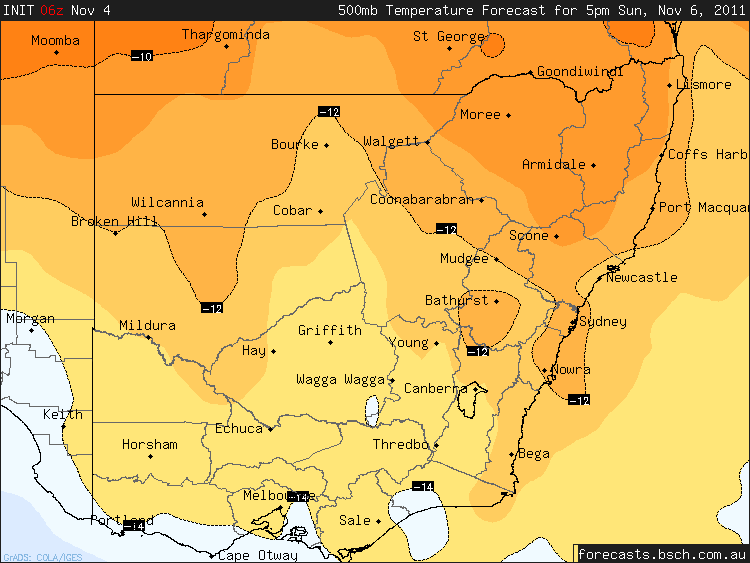
Are we headed for a ridge pattern? Usually such a pattern sees storm development progressing further south as the ridge takes hold. Check out the two consecutive days Sunday and Monday according to the latest GFS 06Z model run:
You must be logged in to post a comment.
The Queensland ridge looks set to block for another week – good time a family holiday there. For my region, an upper trough may just clip NE NSW during Monday. GFS has convective type precip most afternoons though shear will be poor. Looking good for some central NSW storms next several days.
Definately looks good but surface moisture may end up being a negtive factor but if it isn’t then this could be a significant event. So far I have seen GFS plot as much as -9.5 Lifted Index with 3500 CAPE next week with good turning windsheer so there is obviously plenty of potential. To be honest I haven’t been this excited about an inland storm chase since some of us encountered strong supercells over 2 days in December 2005 around Nyngan.
Hi Jeff,
Given the relatively warmer upper level temperatures, moisture is critical in calculating CAPE values. The values predicted from memory by GFS is 20.5 dew points. Bring it down to say 16 dew points brings the CAPE on the same sounding profile to just under 1000 CAPE value. So let’s say it is somewhere in between.
Regards,
Jimmy Deguara
Hi Jimmy,The Access model for next wednesday is predicting dewpoints in the target area of between 18 ad 20 so if it is correct CAPE values should be high.Jeff.
Sorry, I was also going to say that GFS is not looking favourable on wednesday with lower dewpoints coming into the target area. So we’ll have to wait and see. GFS has so far been the least accurate with dewpoints so maybe we are in for a nice change?Jeff.
Well things fired up around Sydney today with at least one cell tracking in from Windsor towards Thornleigh. Lots of thunder but I didn’t see any lightning, we got about 10 minutes of quite heavy rain there. Radar seems to show other cells got going further up the coast, and a big band tracking through the Wagga area down to southern Victoria during the afternoon.Tomorrow is hopefully going to be a bit better though.
I watched the cell as it moved over Windsor but it weakened as it moved further east. We only got a shower from it as we were on the back end.
The cells in Victoria near the border with NSW popped up rapidly and I guess did not last that long in intense phases.
Regards,
Jimmy Deguara
See : 128km Radar Loop for Yarrawonga, 03:00 06/11/2011 to 11:00 06/11/2011 UTC
Nice little cell popped up just to the W of Wagga this afternoon and produced this interesting feature. I’m not sure if it was rotating or not, so it may be a funnel or may not be. Probably just scud .. :)
Radar image at the same time.
Hi Nathan,
Thanks for posting the image!
Hard to tell exactly from one image but the feature is smooth – scud is usually rather ragged. Video often can be used to distinguish features. The bases were high today and that is visible in the photograph. Bases funnels are possible on days with high instability.
Regards,
Jimmy Deguara
No worries, and thanks for the feedback. :)From a distance it did look quite jagged, and then it seemed to become smoother as it got closer.


I drove from Sydney down to Wagga Wagga then south to Henty for a storm chase on 6 November 2011. The storm I intercepted and shown in the photo is a cluster of storms shown in the radar image provided above in the post by Jimmy. I am beside the Olympic Way barely outside the northern approach to Henty township (NSW) looking south west.
While the shot suggests possible significat cloud features, I must advise that I did not see evidence of actual funnel clouds. It is part of a shelf cloud I observed moving south east. I am north west of it looking south west. It makes for a good photo and that feature shown was brief.
That storm produced ocassional lightning and a heavy downpour. I drove into it south of town between Henty and Culcairn and drove in and out of heavy rain showers. That storm moved to the south east gradually weakening in nature.
Earlier that afternoon, I did intercept a small storm at Wagga Wagga. That was high based and I remember it being rather hot and dry in that region prior to that storm. The storm produced a shower that passed over the southern parts of Wagga Wagga City but went into decay south east of the suburb of Lake Albert.
Here is a photo of a lightning strike from the same storm. It was not very lightning active and I struggled to obtain any lightning images from it. Using my Sony Camera, I managed to obtain this image provided.
I remember watching an increase in lighting flashes as it passed east of Culcairn but light rain and an easterly wind at the rear of the storm prevented me from taking any further images.