 Following on from the maps and plots provided in the various posts, here are some interesting weather and temperature facts and figures regarding the current heatwave episode.
I have managed to find a list of the towns that have experienced the highest daily temperatures since 1 January 2014 through to 14 January 2014 (Courtesy from the BOM / Weatherzone 15/1/2014).
Note:- The highest official temperature recorded occurred at Oodnadatta (South Australia) in January 1960 being 50.7C. That is being challanged but not exceeded.
January 1 Tarcoola (SA) 48.9C.
January 2 Moomba (SA) 49.3C.
January 3 Walgett (NSW) 49.1C.
January 4 Lockington (QLD) 45.7C.
January 5 Emu Creek (WA) 45C.
January 6 Learmouth (WA) 46.1C.
January 7 Leonora (WA) 44.6C.
January 8 and 9 Onslow (WA) 48.7C and 48.2C respectively.
January 10 Learmouth Airport (WA) 46.9C.
January 11 Murchison (WA) 47C.
January 12 Kellerberrin (WA) 47.5C.
There is a claim being made of 50C but not proven at Meka Station (WA) (Not official).
January 13 Paraburdoo (WA) 45.8C.
January 14 (Appears to be Keith in South Australia at 47.2C but not confirmed).
Some extremely hot days but the 50C mark is not broken despite possible claims made. This is similar to what occurred during the January 2013 heatwave.
When reviewing individual weather stations some interesting weather phenomena is occurring. For example:-
Cabramurra in the Snowy Mts of NSW at 1,500 metres in elevation - On the 15/1/2014, the weather station recorded a maximum of 29.7C showing that the heat is impacting the Snowy Mts. Observatory Hill (Sydney) close to sea level reached a top of 28.4C due to sea breezes and there is a weather station near Bradleys Head in Sydney Harbour recording a maximum temperature just over 24C. The heat is not affecting the coastal fringe but impacting higher elevations inland to an extent where it is warmer in places of the Snowy Mountains than in Sydney Harbour.
Similar readings have been occurring at Mt Ginnini (ACT) although it has been cooler at Perisher Valley due to elevation.
Melbourne:- The forecast is for 4 consecutive days of 40C which is rare. I am aware of a 1908 heatwave where 5 such days occurred in a row but it is doubtful that this will be broken. It reached 42.8C on the 14 and 42C on the 15 but after 3 pm, a weak wind change to the south did cool the city and much of coastal Victoria. The forecast for Melbourne is 44C for Thursday 16 January.
The current heat episode is strong across Northern Victoria and Southern NSW.
Albury:- The maximum daily temperature for the period 11 to 15 January is 36C, 38.9C, 39C, 41.2C and 41.3C (Already 4 days of 38C plus temperatures and more to come).
Mildura (North West Victoria) for the same period in order follows as 39.3C, 36.7C, 42C, 45.2C and 43.6C (Approx).
Bendigo (Central Victoria) in order of days reads as 35.2C, 35.5C, 38.8C, 43.8C and 42.3C.
Griffith (Riverina of NSW) in the same order 36.2C, 37.8C, 40.7C, 41.3C and 41.8C.
There are some warm nights occurring incuding a minimum of 26.4C at Griffith on the morning of the 14 January but the places reviewed have not experienced excessively hot nights although this may change.
A number of fires have broken out in places due to dry thunderstorms and lightning strikes. I will be in the Snowy Mountains early next week and it will be interesting to see what impact this heatwave may have across the region
Hi Harley, another significant observation from this event was from Melbourne last night. The station there came extremely close to breaking the 24 hour minimum temperature for January. I think the minimum to 9am this morning was 28.6 and i searched the record and found a reference to 28.8 being the record.
Thanks for the information Harley. Now with all this heat, interesting how the Oodnadatta record still stands since 1960.
Wow! We can say that Australia has been rather hot over the past month!
Some additional facts on the heatwave for the 16/1/2014
I have found the following unusual temperature recordings for the day.
1 – Mt Ginnini (Act). This weather station sits approximately 1,760 metres in elevation. The maximum temperature there today was 30C to 30.2C. The minimum temperature was 18C at 12 am.
Compare this to Moruya on the South Coast near sea level (Max 25.8C and min 18.5C).
Then compare to Canberra (Max 38.8C and min 15.3C).
2 – Cabramurra being Australia’s highest town reached 31.3C with a minimum of 21C. That minimum is warmer than Canberra and Moruya. It was 4C warmer here than at Observatory Hill Sydney and the overnight minimum was almost the same as that recorded at Observatory Hill.
3 – I have also looked at Falls Creek (NE Victoria where the same is occurring). The maximum temperature reached 29.2C with a minimum temperature of 19C. This weather station sits 1,765 metres on Mt Mc Kay (Or known as Falls Creek).
The heatwave is causing some unusual temperature recordings that under normal conditions should not be occuring.
4 – Mildura (Mallee region of Victoria) – The temperature was still 40.3C at 8.30 pm 15/1/2014 and 30C at 1.30 am 16/1/2014.
5 – Albury Airport. Today it reached 43C but it was still 39C there at 8 pm (Wed night) and 30C at midnight.
6 – Deniliquin. It reached 43.7C today but the temperature was still 30C at 2 am, 26.8C being the minimum and 31C at 8 am and 41C by 12 noon.
It reached a maximum of 27.5C at Sydneys Observatory Hill with a minimum of 21.3C as a comparison but up to 37C at Penrith (Western Sydney).
It does suggests the coast is being spared any of this heat but the unusual recordings occurring at high elevations is amazing.
Again much of Victoria did swelter in 40C temps including Melbourne and Adelaide but it did not reach 46C in Adelaide as forecast but instead 43C to 44C occurred.
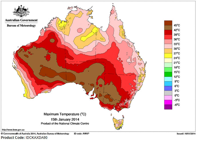
I have also added the maximum temperature plot for the 15/1/2014 to show the maximum temperatures. It clearly shows where the strongest heat is occurring. Off strong contrast is how the coast along eastern Australia is spared the worst of it.
The worst affected area for the 15/1/2014 in south eastern Australia is western and north western Victoria followed by south west NSW. It also shows much of South Australia and Western Australia being affected by the same system.
There is also a small red mark (36C to 39C range) near Sydney which would be Penrith because it did reach 38C around Penrith on this day.
Thanks for the interesting comparisons again Harley posted on the website comments. It would be interesting to note if a specific or predominant wind direction involved was able to advect warm over the ranges near Cabramurra.
Following on from my earlier posts, I have looked at some weather stations across Victoria and New South Wales for the 17/1/2014 and I have discovered some more unusual weather phenomena worth considering.
Again the southern inland region of New South Wales and much of Victoria has sweltered in maximum 40C plus temperatures for the fourth day running.
A cool change is now crossing Victoria ending the current heatwave conditions at least across the southern part of the state. In the meantime the unusual temperature recordings include the following:-
Melbourne (Olympic Park) – Max temp of 42.2C at 4.30 pm under NW winds. At 4.42 pm under SW winds at the leading edge of the wind change, the temperature had fallen to 36C. The minimum temperature was 24.7C.
Geelong – A maximum temp of 43.1C and 42.5C at 2.30 pm. The cool change at 2.36 pm saw the temperature drop to 38.9C. It reached 41.6C at 11.30 am.
Note:- It took two hours for the wind change to cross from Geelong city to Melbourne city considering both cities are close to one another.
Ballarat – It reached 39.1C at 3.12 pm following a low of 24.3C at 2.30 am.
Albury – Maximum of 42.2C (Four days in a row of 40C plus temperatures). It was 31C at 2.30 am before dropping to a low of 22.5C.
Falls Creek (Mt Mc Kay) – It reached a maximum of 27.4C and a minimum of 19.7C at 6.30 am. This is impressive given its elevation at 1,765 metres which is warmer than towns along the NSW South Coast at sea level such as Moruya.
Deniliquin (NSW) – A maximum of 43.1C was reached but was an amazing 30.5C at 4 am this morning before dropping to 24.5C. However at 8.30 am, the weather station had recorded 38C.
Mildura – It reached 43.8C by 4.30 pm and was still 43C by 6.30 pm. At 8 pm on the 16/1/2014, it was still 40.5C. The minmum fell to 26.3C.
Strange readings at Mt Gambier in South Australia – The minimum temperature occurred at 11.30 pm (16/1/2014) being 25.2C. By 2 am, it had risen to 27.4C then to 27.8C by 4.30 am and 28.4C by 5 am then to 29C by 7.30 am to a morning peak of 32C at 9.09 am before a weak wind change stalled the rise. A top of 33.7C was reached by 4 pm before the cool change took hold.
Hamilton (Victoria) – A peak of 38.9C by 11.30 am before the cool change.
Cape Nelson Lighthouse (Southern Victoria) – It was 31C at 3 am before a minimum temperature of 28.6C at 6 am. It rose to 35.6C by 9.47 am before the cool change arrived.
Cabramurra (Snowy Mts of NSW) – It reached 31.2C with a minimum of 20.1C. Compare to Moruya on the New South Wales South Coast which had a minimum of 14.3C and a maximum of 26.7C at 2.30 pm. Sydney city (Observatory Hill) reached a maximum of 27.2C at 3.30 pm with a minimum of 21.4C. This is amazing for Cabramurra being Australia’s highest elevated town when compared to Moruya and even Sydney city both of which are close to sea level.
It appears that enough heat has been advected over the Snowy Mountains to cause this whereas the coastal fringe has been affected by the cooler NE sea breezes capping the temperatures.
If one was to sample more weather stations, it would soon reveal the true extent of the heat including some strange and unusual readings. The cool change will impact on the figures although it is understood that there is one more very hot day for NE Victoria before cool air arrives in that region late Saturday.
The maximum temperature plot for Australia for the 16/1/2014 shows that a swath of south west NSW had temperatures between 42C and 45C. This spread across much of western, northern and southern Victoria.
Across southern Australia, only the east coast of New South Wales and far eastern Victoria was spared the worst of the heat.
The hottest locations were three regions including a small area east of Adelaide around Murray Bridge, northern Spencer Gulf area around Port Augusta and the western border with Western Australia. Here maximum temperatures reached or exceeded 45C.
Additionally, the Pilbara region of Western Australia was hot.
Northern Territory, most of Queensland except the south west and Tasmania are largely avoiding the hot spell gripping much of Australia for the 16/1/2014.