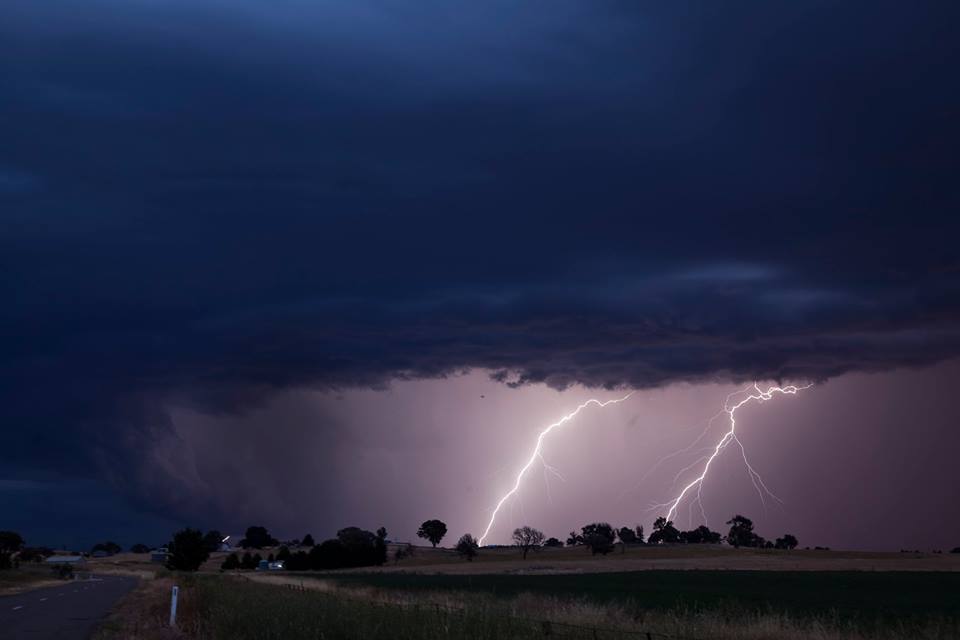
Lightning near Gunning 1st December 2014More storms once again developed over the southeast part of the country including near Sydney. Moisture was a problem for the most part and shear to the north was not as ideal. There were numerous storms near Braidwood and parts of the Southern Tablelands. Most of the more intense storms developed on or after sunset with frequent lightning a feature in some of the storms and this including some hail cores.
4 thought on “Severe Storms southeast central NSW 1st December 2014”
I chased with Jimmy and Shane for the day and I was the driver. Looking at my photos and fuel receipts some interesting facts emerge:-
– I drove 763 km in a space of 14 hours with many stops.
– We documented some 9 storm cells of various intensity, shape and structure.
– Many of the daytime storm cells were relatively small but had contrast to them.
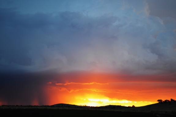
The highlight of the day is the evening storm at Gunning with its colorations and contrast. That turned out to be a great move to get that for the evening.
There was also a night time storm at or near Marulan that contained hail. It was the first time I have driven through hail at night and it made driving tough for a while but all part of the fun.
Some of these storms produced substantial but localised rainfall.
It was amazing to see storms erupt at sunset. I have not seen that occur in a number of years.
Thank you Jimmy and Shane for making this a great day.
I will add some photos to this post.
The storm chase took us from Blacktown to Mc Donalds north of Marulan then to Robertson where we intercepted a small cell that had a short lift span.
From there we went to Bowral to view developing storm cells then south to Goulburn, Braidwood then back to Goulburn, Gunning then returned home.
I am also glad my umbrella came in handy during this chase which allowed Jimmy to film storms without getting his camera equipment wet.
I added the photo above to show a rain shower lit by the sun which I found interesting. That produced more rain than I expected as it passed over us. My umbrella came in handy at this point.
The sunset storm is my favourite and it made the drive to Gunning worthwhile. I did not go for lightning in these shots. Instead, I enjoyed the colorations and glow of the setting sun through the storm cell.
The storms look small in the photos but some of these certainly produced big rainfall totals especially after dark when storms truly developed.
Some heavy falls include:-
Mt Gray at Goulburn – 63 mm.
Tomerang – 57 mm.
Nowra – 54 mm.
Grassy Gully – 50 mm.
South Coast
Belaura – 63 mm.
Bendethera – 50 mm.
Some of these places are tucked away into the coastal range and hills where access is more difficult.
Hail storm Wodonga
During this storm chase, we became aware of a hail storm event at Wodonga during the afternoon. I have since viewed the local newspaper and photos and they show hail fall of 2 cm and approaching 3 cm in size but there is no evidence to show anything larger. According to reports, there was no significant damage in that region.
I chased with Jimmy and Shane for the day and I was the driver. Looking at my photos and fuel receipts some interesting facts emerge:-
– I drove 763 km in a space of 14 hours with many stops.
– We documented some 9 storm cells of various intensity, shape and structure.
– Many of the daytime storm cells were relatively small but had contrast to them.
The highlight of the day is the evening storm at Gunning with its colorations and contrast. That turned out to be a great move to get that for the evening.
There was also a night time storm at or near Marulan that contained hail. It was the first time I have driven through hail at night and it made driving tough for a while but all part of the fun.
Some of these storms produced substantial but localised rainfall.
It was amazing to see storms erupt at sunset. I have not seen that occur in a number of years.
Thank you Jimmy and Shane for making this a great day.
I will add some photos to this post.
The storm chase took us from Blacktown to Mc Donalds north of Marulan then to Robertson where we intercepted a small cell that had a short lift span.
From there we went to Bowral to view developing storm cells then south to Goulburn, Braidwood then back to Goulburn, Gunning then returned home.
I am also glad my umbrella came in handy during this chase which allowed Jimmy to film storms without getting his camera equipment wet.
I added the photo above to show a rain shower lit by the sun which I found interesting. That produced more rain than I expected as it passed over us. My umbrella came in handy at this point.
The sunset storm is my favourite and it made the drive to Gunning worthwhile. I did not go for lightning in these shots. Instead, I enjoyed the colorations and glow of the setting sun through the storm cell.
The storms look small in the photos but some of these certainly produced big rainfall totals especially after dark when storms truly developed.
Some heavy falls include:-
Mt Gray at Goulburn – 63 mm.
Tomerang – 57 mm.
Nowra – 54 mm.
Grassy Gully – 50 mm.
South Coast
Belaura – 63 mm.
Bendethera – 50 mm.
Some of these places are tucked away into the coastal range and hills where access is more difficult.
Hail storm Wodonga
During this storm chase, we became aware of a hail storm event at Wodonga during the afternoon. I have since viewed the local newspaper and photos and they show hail fall of 2 cm and approaching 3 cm in size but there is no evidence to show anything larger. According to reports, there was no significant damage in that region.