
What can I say! I am stunned about the way things unfolded today. Even when I spoke to David prior to the chase was anticipating to end up at Tea Gardens with some high contrast base images!
High based storms were the order of the day and there were some earlier high based storms to the west of the region. 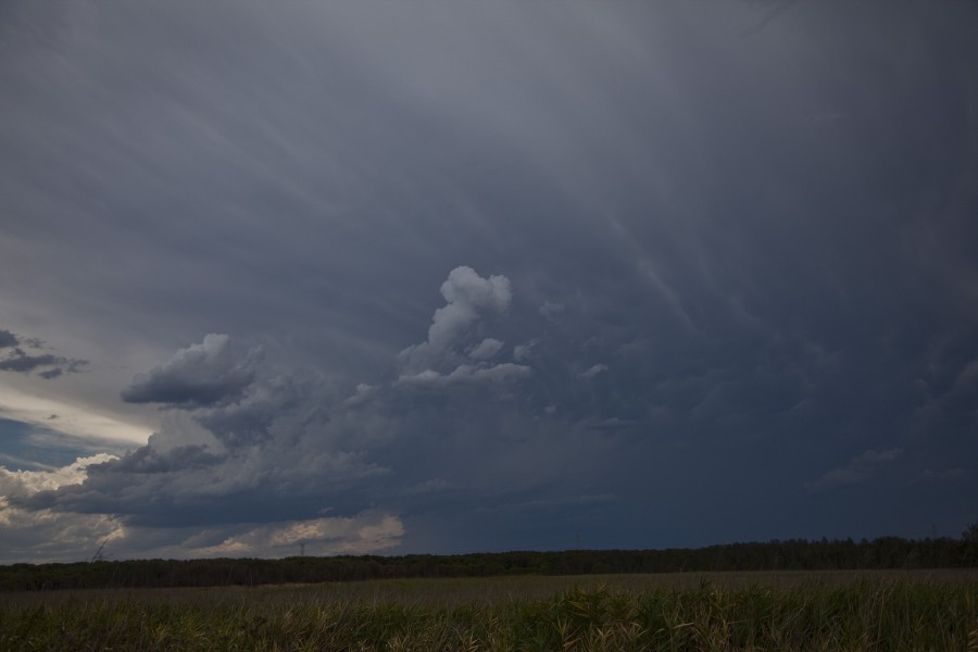
 I did try intercept the earlier storms as they aimed for Bulahdelah (although I was half guessing they would not make the trip). I kept reminding myself that my target was the Nelson Bay region. These high based cells collapsed so I quickly re-positioned in the Tea Gardens area awaiting some other storms that had developed observed from my rear vision mirror.
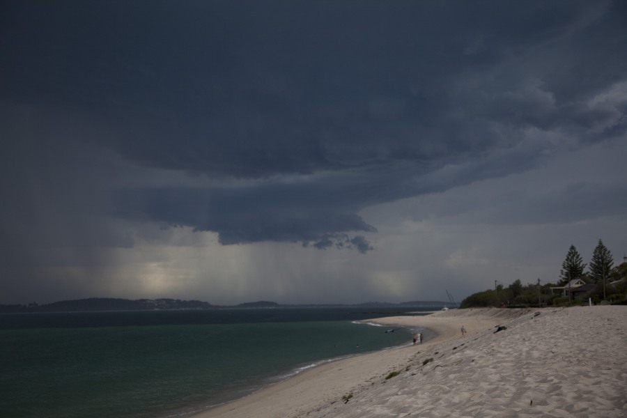
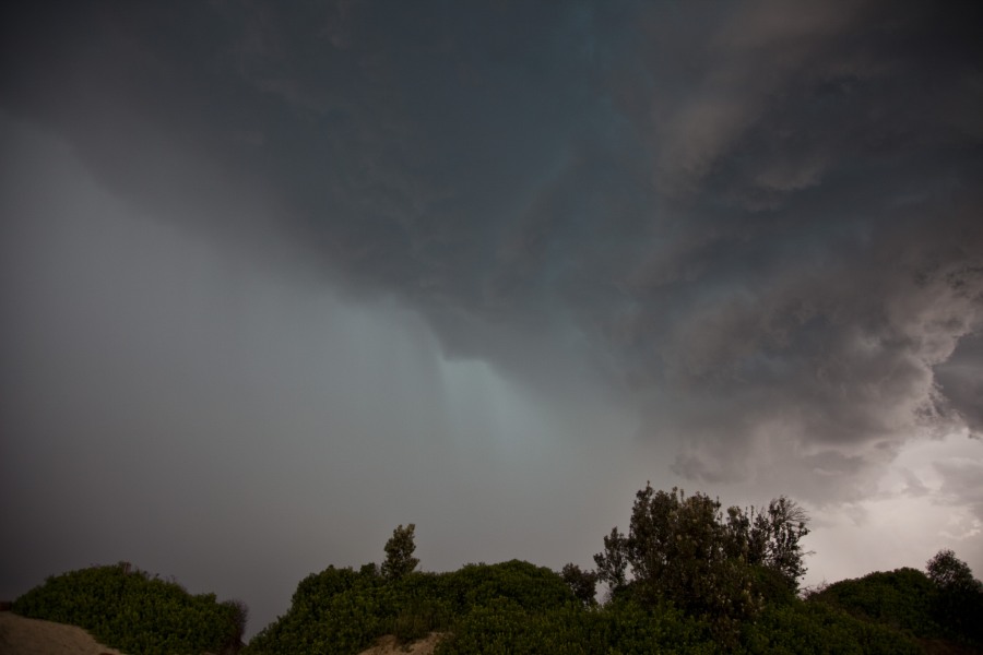
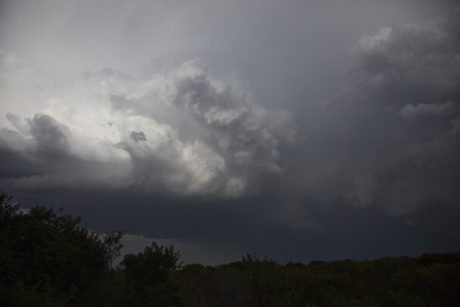
I had never visited the Tea Gardens region prior to this trip. From the time I set myself with Jimelle and Imelda near the beach, the storm structures went from dull to improving to incredible contrast! The green tinge was obvious to anyone as they all took pictures and videos of the event! The storm seemed to intensify as it neared me passing through Nelson Bay region.
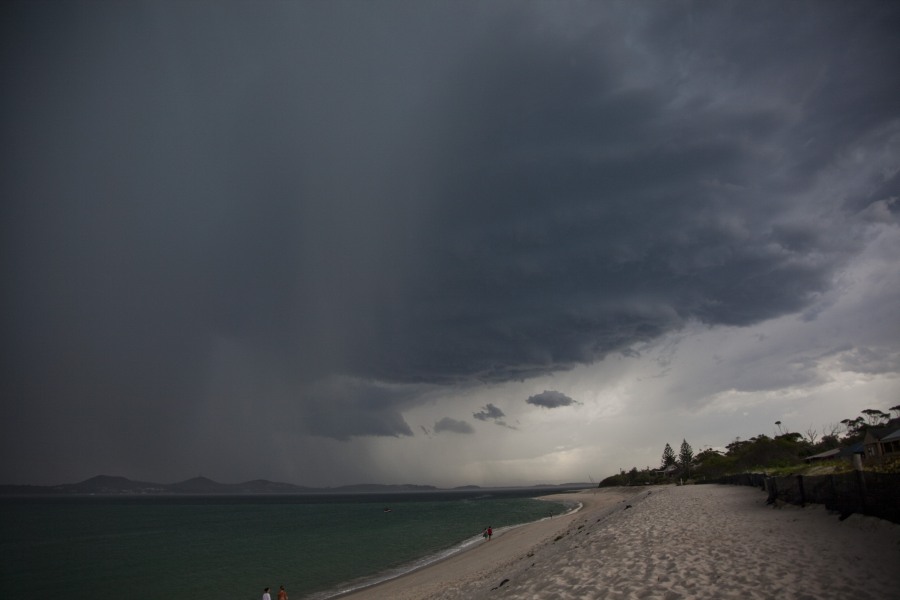
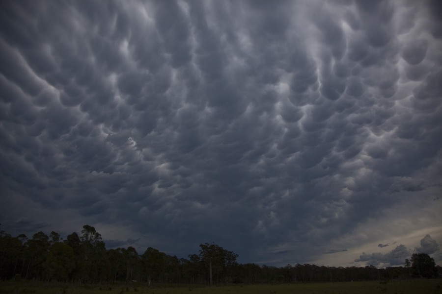
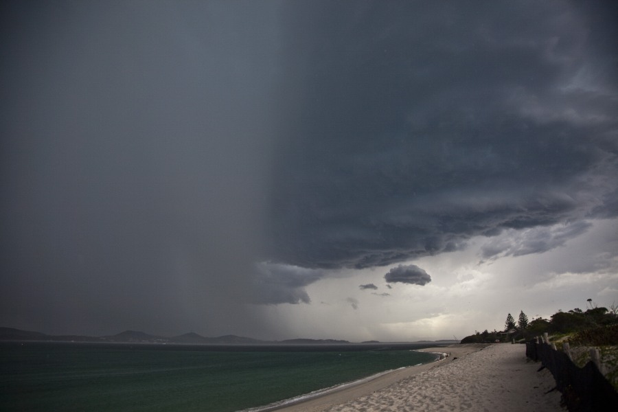 I hope the video did the lightning justice as staccato bolts interrupted the base in a barrage! The hail shaft was dense and so localised. We missed out on the hail but Matt Piper suggested it hailed in his region to the size of at maximum 2cm.
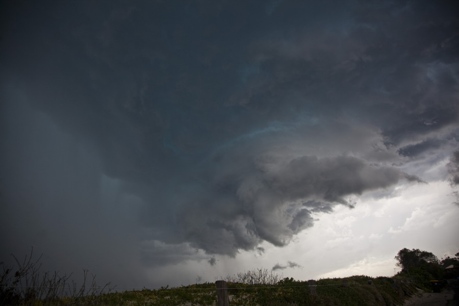
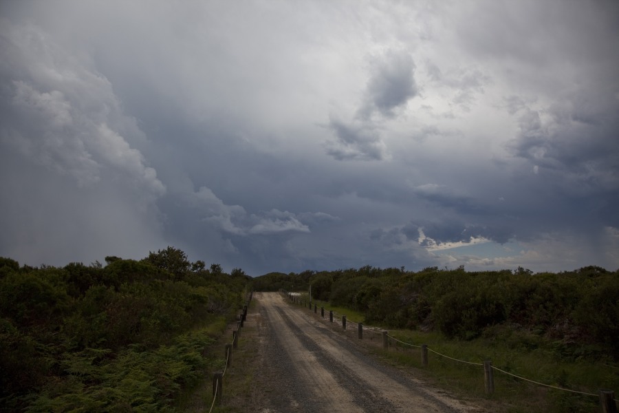
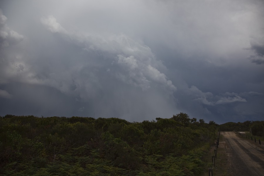
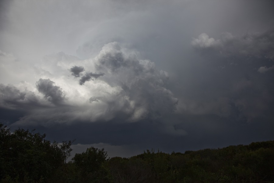
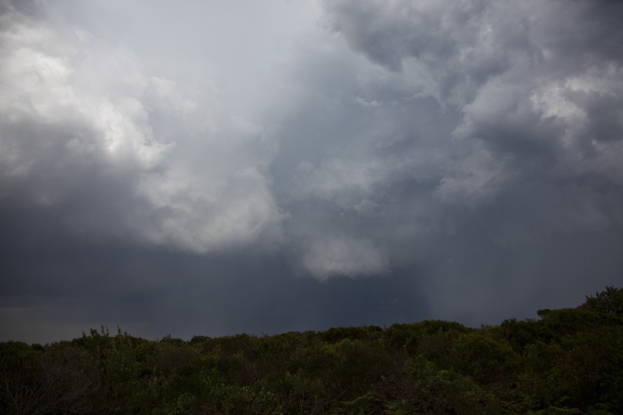 After the storm, I made the mistake of leaving the beach and heading north. The National Park made it difficult to see the bolts and base features. Once I found a half decent opportunity, I took it. The storm still kept going up the coast at this point developing along the flanking line.
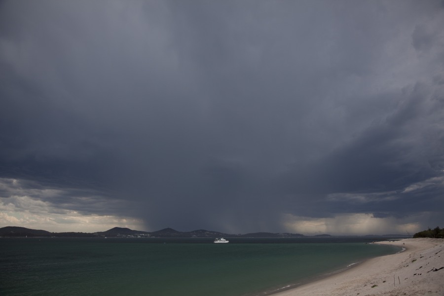
See : 128km Radar Loop for Newcastle, 04:00 28/12/2012 to 12:00 28/12/2012 UTC
Here is a good example for the newbies wandering why there was hail with this storm and yet no black on radar. The Nelson Bay region is very close to the radar so the radar does not exhibit the best echos.
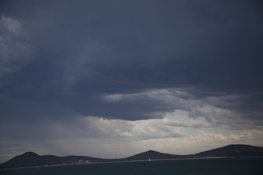
Taking a look at Sydney's radar, a different story. Although fairly distant, the storm can be seen in a split with the left mover slowing down and intensifying and the right mover moving off the coast. Was this a boundary interaction? Was it a supercell? What are people's thoughts? The period when the cells would have been splitting.
See : 256km Radar Loop for Sydney (Terrey Hills), 01:00 28/12/2012 to 12:00 28/12/2012 UTC
Yet another storm chase – the green in this storm was amongst the best for some time! A pleasant surprise enhanced by the triple point I guess!
Beautiful pics there jimmy
Great stuff. Hawks Nest was my target too, but I got sucked into the line coming in from out near Singleton so I went up Bucketts Way. And of course.. it fell apart. So I headed east towards Nabiac and thankfully hung around there for a bit hoping the storms would move up the coast. As the storm left moved/developed on the flanking line it showed some nice base features. CG’s were also going off at an incredible rate. Maybe this was even a wall cloud for a brief time.. you be the judge.
Bit more outflowy now
At Forster as it was weakening. Pretty low topped. My friend at Smiths Lake reported 2.5cm hail, I drove through there on the way home and plenty of leaf litter.
I was right underneath the storm that Jimmy photographed here in Salamander Bay and received hail mostly around 1 to 1.5cm with some stones of 2cm. You could hear the hail coming from down the street and then bam it hit. It hailed for around a minute or so before the storm moved off to the east and intensified further over Nelson Bay. The lightning was almost all cloud to cloud before hitting us and then plenty of CG’s after moving away. The green colouring as has been noted by Jimmy was very pronounced and the contrast was beautiful as the storm moved away due to the sun briefly coming out. I went for a quick drive around the Corlette and Nelson Bay areas after the storm, but couldnt find any signs of significant hail damage apart from a slightly increased amount of small leaf litter compared to my location in Salamander Bay.
Here are some photos of the storm as it moved away from my home in Salamander Bay along with some hail pics.
Another one
The line of white cloud in the top of this image was moving in towards the storm (Moving East)
Nice hail shaft visible :-)
Hail up to around 2cm. This photo was taken at least 10 minutes after the hail had fallen.
I decided to target the Cessnock region and I admit, I saw some spectacular storm cells. Storms were small, high based but contrasts, cloud anvils and colourations were impressive.
Following a small storm just south of Cessnock which produced plenty of thunder during its active phase, I had the choice of driving north towards a much larger cell but another cell rapidly developed close to me so I targetted that one. The contrasts against the blue sky and the anvil cloud tower was stunning.
I chased that to a rural area north west of Cessnock then watched the storm drop a rain shower then slowly decay.
Another storm cell developed nearby and I let that one pass over me. That too had a very interesting dark coloured base. Following that there were a number of storm cells developing in the area all producing great contrasts and colourations and plenty of photo opportunities. Interesting, I could see the southerly change moving north along the coast and the accompanying low stratus cloud with it creeping northwards.
This was one chase where I took more than 100 photos only because I found a good locality where storms were initiating and producing great contrasts, cloud towers and colourations. I did not chase the one towards the north east near Nelson Bay but I think I saw that one from a distance.
While this storm was small, I did see a few cloud to ground lightning strikes and plenty of thunder rumbling through the cloud at its peak. This produced some great contrasts across the sky.
Following the first storm, a much larger storm to the north caught my interest. I took some photos of it but as I was thinking should I chase it, another storm developed much close to me. In some ways, I am happy I did not chase it because I would have missed some wonderful cloud contrasts and anvil cloud towers.
This has to be my favourite storm of the day. Not due to size but due to the contrasts and the anvil cloud tower.
The base of the storm.
I chased the storm to a rural area north west of Cessnock and watched it decay. Another storm cell passed over me as shown in the photo and I found the base rather interesting. Some very large raindrops and thunderclaps but no torrential downpour.
Nice pics too Harley ,Ben and matt was going to target the same storm but had to put the family first
The last photo showing anvil cloud towers from a storm that had passed over me. I certainly enjoyed watching the colours. Each storm produced a number a thunderclaps and short bursts of rainfall but they did not last long. I did find on each storm, the cloud tower would glaciate then the anvil would spread rapidly east, south east and north east.
Absolutely awesome structure. Good to know what I missed out on! Enhance the contrast on this and it will be more awesome!
I chased with Michael Thompson yesterday. The target was Nelson Bay or Bulahdelah, that sort of that general zone however we got distracted by the healthy convection in the upper Hunter.. We actually ended up in Muswellbrook briefly, intercepting a high based storm with a few pulsing bolts . The line was rather featureless, however as we followed it back to Singleton it intensified slightly, containing some nice back end features including a brief mid level funnel some great back end updrafts and some solid looking rainfoots. The line collapsed so we headed to Bulahdelah via Dungog and Stroud..
The situation looked crook, however we noted a new cell 40kms to the south near Maitand which contained some scrappy base features… As we entered the hills and jungle east of Stroud we lost sight of the cell to the south for 20minutes, however our next view revealed a whole different storm altogether. It now looked severe, black as, with hints of green, strobing bolts. As we neared Bulahdelah I finially got internet coverage again, noting the storms had just oved off the coast of Williamtown… However all was not lost as we expected a storm to swing to the northeast possibly bringing it over land again.
We noted the much more humid air at Bulahdelah whilst the storm 20kms to our south put on a display of pulsing bolts, a huge number of the as well… We timelapsed the storm for 20minuutes, witnessing some lovely structure.. It was still high based but was starting to get a few more features as it was trying to tap the better coastal moisture. We made the call to shoot to seal rocks, getting within a few kilometres of the storm, and we had the opportunity to core punch it too if we wanted… This was the view of the storm as it neared Seal Rocks ( see image below)
As the storm crossed offshore it started to weaken. It was still very high based at this stage sending down big downbursts still with rainfoots. We also noted rapid cloud motions and some mid level funnels.
Excellent report and series of images Jimmy. Did you track up the beach towards Bombah Broadwater? We enjoyed the same barrage from Bulahdelah!
My first post guys
Jimmy great set of pics, im glad someone other than me got some pics from Hawks Nest, the green in the storm is the best i’ve seen in some years around this area!
Hi Michael, No I had family with me and I just shot the storm as it had a flanking line. A video is getting uploaded as I type of this event! You guys did very very well to get from Muswellbrook to Seal Rocks – with double de-merit!
Eddy, Post some of your pictures please too!
Some edited video of the event
Jimmy
Nice picture!
Where were you Eddy? Is this near the golf course or north of town towards the National Park road?
Jimmy
Posted the video now. Sorry to take so long – I was out before now and completed the process when I got home.
Thanks Jimmy, great video too.
Yes i work at the golf club, so i took what i could get after clearing the players from the course, the photo is over looking the 1st tee looking towards Nelson Bay.
Jimmy where you took those photos up the National Park, you were less than 2ks from the first lake Broadwater.
Cheers Eddy
YouTube footage of storms from the 28th December. First at Muswellbrook, second at Buladelah (had the coastal moisture been thicker we could have had something very nasty), the last another weak cell near Taree.
Best to watch in full HD on YouTube as contrast for the Buladelah storm is much better.
Direct Link = http://www.youtube.com/watch?v=5xuRIyIs3DE
Sorry the Iframe embed cose is not working for me, you will need to follow link
…with Michael Keene.
..near Forster..this low level was desperately trying to feed into storm in a more organised manner, but moisture depth appeared just too thin.
On the Lakes Way road near Smiths Lake
Hi it seems like from the information on this storm, radar behaviour and also discussions with David, this storm near Nelson Bay was sufficiently long lived to possubly be considered a supercell. There was a split into a left and right mover and the left mover slows down!
Happy new year Jimmy :)
I was up at Lansdowne on holidays and was able to go out for the weaker cell as it came across around 730pm. Got some nice close lightning on video and the colour of this cell with the sun behind it was amazing!
This is the same cell you can see at the end of Michael’s footage. Very high based but a nice base all the same!
Here’s a short time-lapse video of the storm arriving with a nice and close cloud to ground lightning strike.
This is a compilation of lightning after the cell had passed further east the sun had set. Some nice powerful bolts, some of which match up with the still shots.
Harley, do you have any updraft images of those cells?
Jimmy
Harley, great that you documented these cells and I like the updraft strength and crisp towers! Well done!
Great colouration and scenery to match – I think I recall this particular paddock not far from the place you were staying!
It was Jimmy, I had to keep checking my LCD to confirm the colour’s but the camera was spot on.
Here is a couple of lightning images after the storm had moved east.
And another one.
I love you video Jimmy, interesting structure developed and the lightning was awesome! You had a box seat under the main event!
Which way are you looking? This cell looks amazing and it would appear to be the only really surface based storm of the day. What is the time for this image?
Hi Jeff/Ben,
I assume this formation has developed near or out to to sea somewhat? Or has the change interacted with it?
Hi guys.
This was taken from Nabiac looking SSE at approx 5:20pm. The feature formed around 5:05pm and begun weakening at around 5:25pm (see following photo). It did look pretty awesome for a while, and occurred when the storm begun to do a ‘left move’. I was tempted to call it a supercell but when the feature weakened quickly I wasn’t so sure.
Jimmy, I provide some additional images of updraft towers on the cells. I took a number of photos of updraft towers and their contrasts.
Then this one. The cloud towers are sharp and clean against the blue sky.
Finally this one. This provides a good indicator of the conditions and the behaviour of the cloud towers away from the coastal strip. For most part, storms were small but photogenic throughout the afternoon.
All the time the temperature was over 30, I think 33C to 34C throughout the afternoon prior to the wind change. Winds were NNE but did swing more NW later on during the afternoon then after 5 pm, the SE wind change came through.
Better late then never, i have manged to put all these photo’s into a short time lapse.
Its a little bumpy to start with.
http://youtu.be/Ui4N_LHgYS0