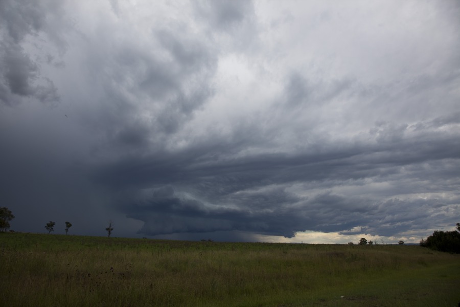
 I had a little spare time to chase locally and headed out to local look outs watching the Penrith storm intensify and become organised. It did for about half an hour or so and seemed to indicate wall cloud behaviour consistent with the indentation like hook on radar (I guess inflow notch feature) on one or two frames. There was some inflow. But as per usual, outflow developed once the separation began to disappear near the notch area.
Regards,
Jimmy Deguara
Here are a few more images from the storm yesterday.


Some lightning photos from McLeans Ridges, NSW looking towards a Border Ranges storm on Saturday 11th Feb. I only saw two CGs – the rest of the lightning was in-cloud or anvil crawlers like the examples shown here.
Sunday 12th February 2012:
A very noisy storm over Nimbin with quite a lot of CGs observed from McLeans Ridges. The storm had tracked NE from west of Casino and across Kyogle, then interacted with other stuff and then propogated almost south. It had a very green appearnce for a while.
There was a snakey funnel cloud over Nimbin Rocks too.
MB
Great little storm yesterday at Penrith as you saw Jimmy. I didn’t get out early enough and only chased the end of it but better late then never!
Today however was phenomenal and I chased from 1pm and managed to chase the Supercell through Penrith from start to finish. I got some great footage and to be realistic, the storm core I drove through at Penrith and then Castlereagh was the most intense with the lowest visibility of any that I have ever experienced. I must have managed to get the most intense part of the core perfectly. At one point the visibility was zero and I had to stop my car as I couldn’t see past the bumper bar! It’s gonna take a while to get everything up but there is some great footage and images.
Here is a video of the last wall cloud phase of the Penrith Supercell.
http://www.youtube.com/watch?v=lSg8ncKQ9MU
Here is another video from yesterdays chase. This is when I first entered to core of the storm between Mulgoa and Glenmore Park
http://www.youtube.com/watch?v=Rc3S4aWAgrY
I undertook a storm chase around the Southern Tablelands on the 12 February. Late morning, a storm cell built around Moss Vale then it moved north east. As it did so, I was able to see the development of a shelf cloud. I intercepted the storm at Berrima, then followed it back to Bowral. I found roads that permitted me to keep pace with the storm. This storm seemed to intensify as it moved north east. I remember experiencing heavy rainfall at times, wind and even sporadic small hail. I observed ocassional lightning strikes especially to the east.
I made numerous stops between Berrima and Tahmore to photograph the storm cell and at one point I struggled to keep ahead of the advancing rain squall. Eventually I had to let the storm go because I could not find a suitable road that led north east. That storm crossed the coast somewhere near Wollongong.
Following that, I drove to Picton and identified another storm cell to the north over Western Sydney and one to the south. I elected to go back towards Mittagong because I decided not to chase storms into the built up areas of Sydney.
After driving through a collapsing storm cell near Bargo, I drove to Mittagong and found an open park near Bunnings where I was able to observe a crisp and rather photogenic cumulonimbus tower build south of town. I could hear thunder rumbling through the cloud tower as it built and matured. The anvil eventually spread out then merged with other cloud anvils but I managed to capture the best of that cloud tower.
Following that, I had a short break at Mc Donalds for dinner, then drove to the top of Mt Gibraltar overlooking Bowral and Mittagong and watched as a storm cell passed right over the hill. While there was no hail, it did produce substantial rainfall and I observed much water flowing off the road way. This concluded the day. There were other storms nearby but these seem to be weakening and hence I returned home.
My second photo shows my first storm of the day at its peak. I managed to drive ahead of the rain squall to get this shot. The sun is starting to shine and it makes for a great contrast. This was taken near Tahmoor looking SE. I am on Rememberance Drive.
My favourite photo of the day taken at Braemar (Mittagong) shows what is technically my third storm of the day looking south. I found a park which is open and provides views towards the south. This storm tower provided great contrast. I did not chase it as I enjoyed watching the spectacle. This eventually merged with other cloud and shower cells but while in this state, it made the sky worth watching.
Harley, that was a great day! Certainly a nice surprise!
Here is another image still with staccato lightning
I added a video still from this date of a nice staccato lightning descending from the front of the structure!