Much needed rain is anticipated across region of South Australia, then western  Victoria and finally southern NSW by the 11th April 2014. This rain event is in response to a north west cloud band streaming across from northwestern Australia. As these north west cloud bands encounter cooler air aloft, and increased moisture at ground level, this enhances the chances of rainfall.
Farmers in those regions will be waiting eagerly for this system to help ease the drought after watching for about month or more prior other regions in eastern parts of Australia experience drought breaking or at least reasonable falls of rain.
This system is beginning to produce some strong rainfall totals over a long period. Light to moderate soaking rain has been a feature till 9 am across the following regions:-
Western side of NE Victoria.
North Central Victoria.
Northern Country (North of the Great Dividing range).
Eastern Mallee region of NW Victoria.
An area approximately 40 to 50 km into the southern border regions of NSW.
This area takes in the regions around Shepparton, Wangaratta, Echuca, Bendigo, Swan Hill, Finley and Corowa. Widespread falls of 25 mm to 49 mm are common.
The rain has not been torrential or heavy but steady so it will have a significant benefit for the farming regions.
The best falls to 9 am 10/4/2014 include 65 mm at Violet Town, 59 mm at Hillside and Warrenbayne, 54 mm at Broken Weir and 51 mm at Rushworth.
A small area around Swan Hill did well including 55 mm at Swan Hill (Town), 54 mm at Ultima and 51 mm at Kerang.
The good totals spilled into the southern portion of the Murray / Riverina including 48 mm at Tocumwal, 41 mm at Mulwala and 40 mm at Finley. Rainfalls are lighter elsewhere.
This has continued throughout Thursday with healthy totals continuing. The better falls have edged further east including 22 mm at Albury Airport for the 9 hours from 9 am to 6 pm 10/4/2014 on top of the 12.4 mm till 9 am 10/4/14. There are higher totals further west around Rutherglen and Wangaratta.
This system will generate more rainfall and seems to be the Autumn break for this area. The rainfall plot for Victoria till 9 am 10/4/2014 is attached for reference.
This has become a significant rain event for southern NSW and northern Victoria and could be termed “The Autumn Break”. The Autumn break has been relatively rare over recent years and is a term used to describe the first big general rain event following a hot dry summer. It comes from the NW cloud bands streaming from the NW. Given the right conditions as explained in the first post, then they can drop a good amount of rain across the farming regions for a period of 1 to 2 days.
I grew up in southern NSW and remember these rain events. They usually or should occur during March or April following a dry summer and would herald the end of the dry summer and start of the cooler Autumn / Winter months. They are characterised by an extended period of light to moderate rain occurring over a whole day. Rainfall was never torrential but a steady soaking rain occuring from thick nimbo stratus cloud. Rainfall is sustained with intensities waxing and waning over many hours. They are usually the first good rain to replenish the soil moisture and farmers relied on these events to commence the cropping season.
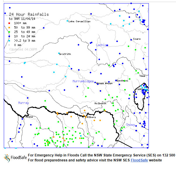
This system has been a classic “Autumn break” producing that steady rain over an extended period falling in the right areas at the right time. As a result, rainfall has been excellent and beneficial. The heaviest falls for the 24 hours till 9 am 11/4/2014 is listed below:-
Yambla (Probably a farm) SW of Gerogery – 86 mm (Highest total).
Wodonga – 76 mm.
Hunters Hill and Geehi Airstrip – 73 mm.
Hume Dam Wall – 69 mm.
Corowa – 68 mm.
Albury Airport – 66 mm.
Tooma Dam – 64 mm.
Rutherglen – 62 mm.
Mulwala – 58 mm.
Jingellic – 53 mm.
Indeed anywhere along the Murray River region from Corowa all the way to the Snowy Mountains have benefitted well on the 10 and 11 April with this rainfall. Follow up rain would be needed in due course. I attach the rainfall plot for the region showing the best falls for the period.