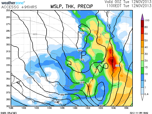
 The heat and dry has been relentless but we hopefully may be ending one of the driest episodes on record. This weekend should see a change move inland through Sydney to Newcastle and with it moisture and storms. The next several days could see some rain and storms as well. The map included is for Tuesday based on the models.
8 thought on “Rain and Storms from 9th November 2013”
Leave a Reply
You must be logged in to post a comment.
Chased the storms in the eastern Hunter and lower Mid North Coast near Bulahdelah today. Unfortunately did not react quick enough to be under or in front of the developing cell that split near Bulahdelah but since it was higher based, it did exhibit some decent hail shafts. Also enjoyed sporadic night time lightning and anvil crawlers at Port Macquarie!
I got out for a pretty dam awesome lightning display from the evening storms that developed near Kempsey .. Lightning rates were very frequent and bushfire smoke made for orange bolts!
Lightning:
more:
more again:
Please find a comprehensive report on this rain event below.
For Sydney, showers started Sunday morning across Sydney’s east and spread to the Hills district as morning progressed. During the afternoon, a downpour occurred around Bella Vista where I was. Prior to the main event overnight, I was able to view BOM rainfall data and determine that the heavy showers had produced at least 8 mm of rain in affected areas.
Overnight Sunday and into Monday, the whole of Sydney had received welcome rain. An area around Blacktown had received the lightest falls for the 24 hours to 9 am 11/11/2013 including 17 mm at Blacktown and Seven Hills, 18 mm around Toongabbie and as much as 21 to 23 mm around nearby suburbs.
There were light falls of 21 to 22 mm around Sydney Airport, Mascot and La Peruse. Heavier falls occurred elsewhere including 41 mm in the city, 44 mm at Penrith and 46 and 47 mm around Manly and suburbs. The heaviest falls were 47 mm at Kurrajong, a rural area near Badgereys Creek and North Manly.
This event was largely coastal in nature with less falls occurring west of the Great Dividing Range. Inland NSW, falls were very patchy and northing occurred on the plains and drier areas further west.
On the Central Coast falls varied from 4 mm at Kulnara to 71 mm at Blacksmith.
Around Wollongong, 78 mm fell at Beaumont and The Cedars.
On the Southern Tablelands, 64 mm fell at Fitzroy Falls. The rainfall penetrated as far west and south as Canberra with 23 to 34 mm falling across the city.
Rainfall was much heavier around Newcastle with 29 to 77 mm common across the city and suburbs.
Further north, a rural area around Port Macquarie received 64 to 98 mm excluding Port Macquarie.
Falls of 25 to 35 mm were common around Coffs Harbour but 63 mm fell at Bellingen and 68 mm at Utungun.
The heaviest falls for the period 9 am 10/11/2013 to 9 am 11/11/2013 occurred around Port Macquarie (City) being 114 mm, Maria River 116 mm and Smokey Cape 100 mm.
Forster had the highest fall of 130 mm.
For the 24 hours from 9 am 11/11/2013 to 9 am 12/11/2013, the rainfall event continued.
Again similar to the previous day, the event was largely coastal with little rainfall penetrating west of the Great Dividing Range. Some light falls did penetrate into the eastern parts of the slopes and plains and the hills of NSW but further west, nothing occurred and it remained dry.
Across Sydney good rainfall occurred especially across the northern suburbs. Around Blacktown where I live some healthy falls of 18 mm to 32 mm occurred including 25 mm at Blacktown.
Lighter falls occurred across south west Sydney, anywhere from 14 mm to 31 mm.
Unusually light falls fell across Sydneys coastal suburbs with 5 mm to 8 mm common and 18 mm at North Manly.
The heaviest falls fell across Hornsby, Parramatta, Carlingford, Pennant Hills and Sydneys Hills District with as much as 54 mm falling at Waitara and 26 mm to 49 mm common.
Away fom Sydney strong rainfall occurred at Canberra with 32 mm to 53 mm common.
South of Sydney rainfall was focussed around Wollongong including 28 mm to 70 mm across Wollongong. Brogen Creek in the hills south west of Kiama had 126 mm while only 30 mm fell at Kiama town itself. Nearby Wattamolla had 104 mm.
The New South Wales South Coast experienced a significant event on this day with the following occurring in towns and townships further south:-
Brooman – 125 mm.
Batemans Bay – 143 mm.
Moruya Beach – 136 mm.
Bodalla – 116 mm.
Argledale – 134 mm.
Merimbula – 104 mm.
Nimmitable – 109 mm.
Bega – 126 mm.
This was concentrated between the coast and the coastal range and it is probable topography played a role as the big falls did not occur further inland.
The event continued into Tuesday with the rain clearing Sydney. I did not take too much notice of rainfall outside Sydney but I am aware heavy showers during the morning dropped another 4 to 7 mm including 6.6 mm at Blacktown where I live.
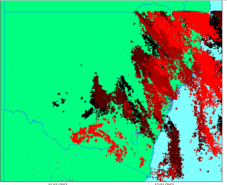
However, there were thunderstorms and a view of the GPATS Lightning plot for NSW identifies some 66,123 lightning strikes across NSW, some close to the Sydney Basin for the period 8 pm 11/11/2013 to 12/11/2013.
Storms featured across much of New South Wales but I was unable to chase as I was at work.
Generally for this event, coastal areas of New South Wales received by far the best or all the rainfall while the inland largely missed out. This has had another positive effect of returning much needed water to dams, streams and helping the fire situation significantly. Finally for western Sydney, it has broken a 4.5 month dry which commenced in July and finally broken during this event of 10/11/2013 to 12/11/2013.