Similar to the previous post, rain continues to drench parts of eastern New South Wales while the south and west of the state remains dry resulting in wide variations of weather.
For the 24 hour period to 9 am 30/12/2020, Mona Vale in north east Sydney was drenched with 105 mm with falls of 73 to 78 mm falling in nearby suburbs.
Constant rain has also featured across other parts of New South Wales and cumulative totals are mounting.
For the period 1 December to the 30 December 2020, Horsley Park in Sydney's west has received 112 mm of rain against an average of 69.9 mm while Penrith has received 117 mm against an average of 65 mm. Furthermore, Sydney City has received 118 mm against an average of 77.1 mm.
Afternoon thunderstorms featured across Sydney and areas further north on the Monday 28 December 2020 although we were in Albury.
Interestingly, following the passage of the cold front in southern New South Wales , large banks of alto cumulus castellatus clouds dominated the sky for much of the morning although this cleared during the afternoon.
During the drive from Albury to Sydney on the 29/12/2020, we left Albury under clear skies. At Wagga Wagga, it was clear and sunny. At Gundagai, small cumulus clouds were observed. Between Gundagai and Yass, more and more clouds were observed and by the time we reached Goulburn, it was cool and cloudy with occasional drizzle patches. We reached Sydney under showery skies.
There has been a distinct dry line between the wetter eastern half and the drier western half centred close to Conroys Gap. Conroys Gap is a pass that rises approximately 650 metres in height being part of a wider north to south range of hills that divides the southern tablelands with the slopes and plains just to the west of Yass. This is where the boundary between the two air masses has been situated over the past few days.
In this instance, the eastern half has seen much of the rain while the south and west has missed the event.
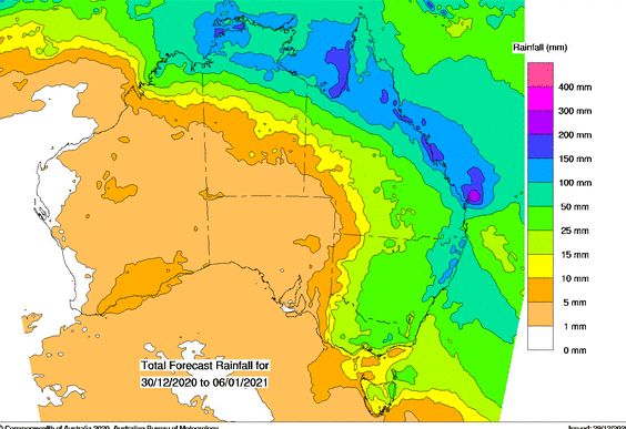
Weather models are now showing and suggesting that some of the rain and storms should start to penetrate further inland thus reaching some of the drier western and southern areas during the period 31 December 2020 to the 6 January 2021. Rainfall models do suggest falls of 25 mm to 50 mm for the drier regions with continued rain for the eastern half of the state.
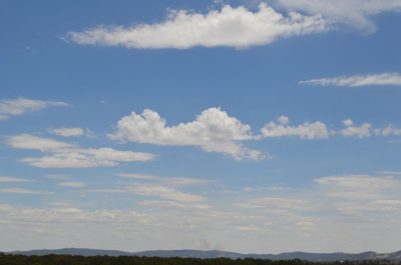
The attached photo taken just east of Albury (27/12/2020 looking west) is showing the typical weather conditions being experienced in southern New South Wales ahead of the most recent cool change being thin high cloud as temperatures soared close to 36C. However with elevated fire danger, fires have been a concern. The plume of smoke from a grass or bushfire is visible on the distant hills. With forecast rain over coming days, the elevated fire danger should be reduced.

The attached model from the Bureau of Meteorology "Water and the Land" site prepared on the 30/12/2020 is showing forecast rainfall up to the 6/1/2021. It is showing that most of New South Wales including the drier areas should benefit from the developing weather system.