
During a five day period between the 13 and the 18 July 2021, a significant low pressure system has been passing to the south of the Australian continent which has resulted in a number of cold fronts passing across South Australia, Victoria, New South Wales and Tasmania.
Each frontal system has provided a continued outbreak of cold wintry weather across the south and rainfall figures are starting to accumulate. Low level snow is occurring across the southern ranges and into the Central Tablelands.
On Thursday evening, one particular front generated thunderstorm activity across the south west part of New South Wales and one strong cell passed over rural areas west of Wagga Wagga. Additionally, two separate storm cells passed along the New South Wales / Victorian state border. The cells brought a high frequency of lightning strikes and the Albury Airport recorded 8.8 mm of rain in 21 minutes and a total of 20 mm from the event.
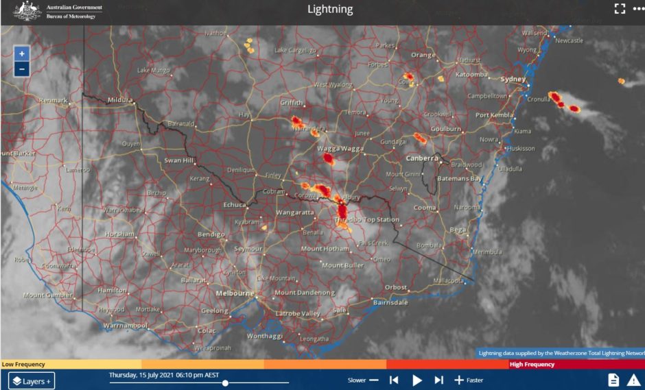
Winter thunderstorms are rare in this part of the state but having storms occur after sunset in mid July makes this event even more unusual.
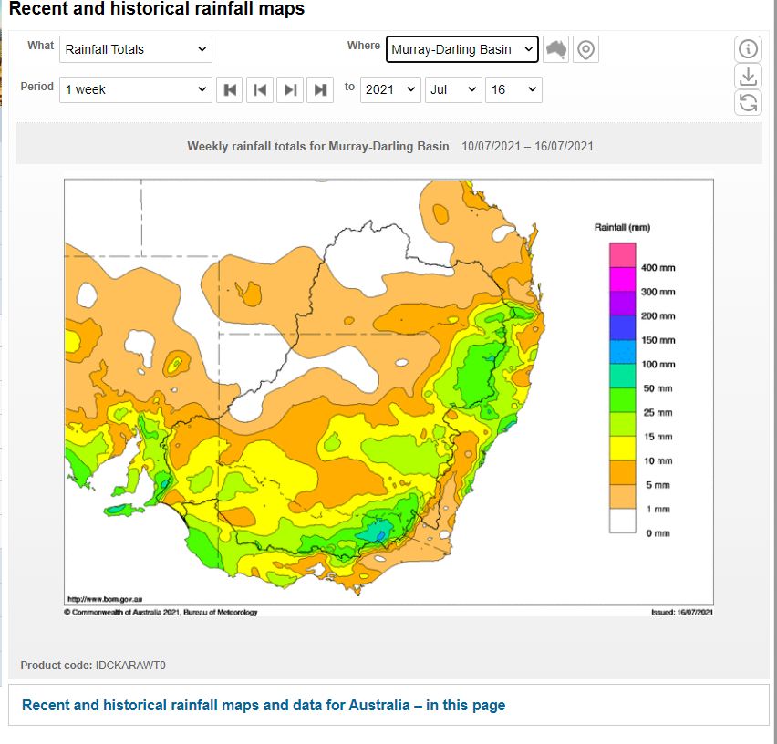
Rainfall accumulations across the five days are beginning to mount although the heaviest falls are relatively localized to the areas immediately to the west of the Snowy Mountains and the mountainous areas of North East Victoria. Accumulations have now reached in excess of 100 mm within isolated areas.
Interestingly, stark rain shadows lie to the east. Air is rising across the ranges and the rainfall is being dropped within the highly exposed locations but areas to the east of the Great Dividing Range have remained relatively dry. Thus, the same locations have been receiving rainfall across the 5 days.
Some notable weather events identified are:-
Roseworthy - (South Australia). The weather station recorded peak wind gusts to 95 km/h between 3.34 pm and 3.42 pm on the 15/7/2021 as one particular front passed through.
Albion Park - (Wollongong New South Wales). The weather station recorded peak wind gusts of 95 km/h between 12.30 pm and 12.35 pm 16/7/2021 as a front passed through.
Moss Vale - (New South Wales Southern Highlands). A peak wind gust of 85 km/h occurred at 12.07 pm 16/7/2021 as a cold front passed through.
Sydney - (New South Wales). A peak wind gust of 80 km/h occurred at 12.41 pm 16/7/2021 as a front passed through.
THUNDERSTORMS
Thursday evening 15/7/2021, thunderstorm activity passed over areas of the Riverina and South West slopes with Albury Airport recording 20 mm from one event which occurred after sunset.
RAINFALL
To date, the heaviest falls occurred during the 24 hours to 9 am 17/7/2021.
Tooma Dam (NSW) - 82 mm.
Perisha Valley (NSW) - 61 mm.
Geehi (NSW) - 60 mm
(All areas are within the Snowy Mountains of New South Wales and much of this would have been snowfall at higher elevation.)
Black Range (Victoria) - 59 mm.
Harris Lane (Victoria) - 53 mm.
Upper Buckland (Victoria) - 50 mm
(All areas are within the rugged areas of North East Victoria).
Outside the regions, rainfall has been lower but accumulative totals are starting to mount such as 50 mm at Albury Airport.
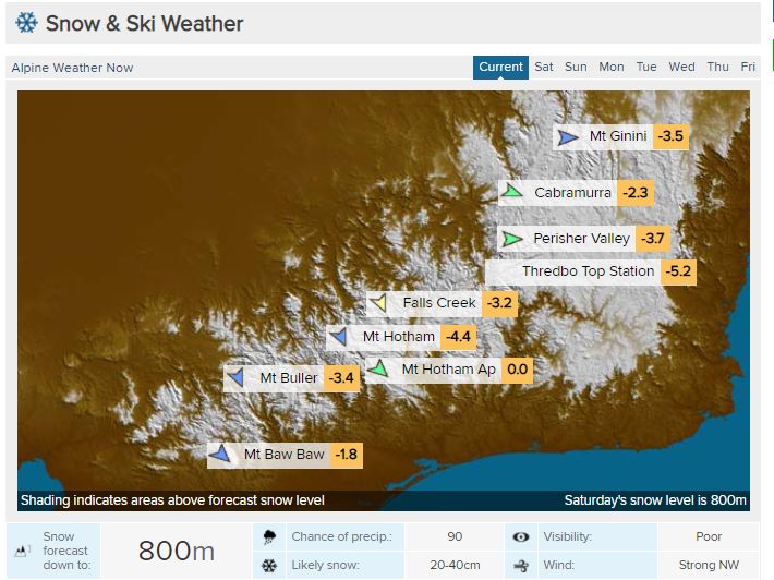
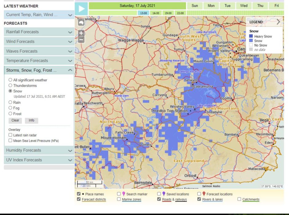
SNOW
The coldest day so far during the event has been the 17/7/2021 due to the wind direction and snow levels have dropped to quite low levels (Approximately 800 metres above sea level).
Some snowfall has occurred around the Oberon region and the weather station here was reading a temperature of 0.8C at 1.10 pm (17/7/2021).
There have also been snow showers around Canberra and even Blackheath.
While light snows have occurred over the Central Tablelands, heavy snowfalls have occurred across the Snowy Mountains and higher areas of North East Victoria.
SUNDAY TO TUESDAY 18 TO 20 JULY 2021
Conditions are expected to ease as the final front clears the state and passes out into the Tasman Sea.
However, during Tuesday 20 July, a vigorous cold front is forecast to pass over Southern Australia that will re establish the cold conditions over the region. However, this system appears to be even colder as snowfalls are forecast to lower to 500 metres above sea level. Snow may even fall again over the Central Tablelands. This system is expected to be shorter lived than the current system impacting the south.