A weather system that brought unusual thunderstorms and even a hailstorm over parts of Alice Springs during the afternoon of Sunday 14 June 2015 moved into Western and North Western New South Wales overnight.
This system produced some worthwhile falls across the north and north west of New South Wales. For the 24 hour period, the best rainfalls were:-
Wilcannia - 30.6 mm.
Trevallyn and Wanaaring - 28 mm.
Tibooburra - 26 mm.
White Cliffs - 16.6 mm.
While not drought breaking, they are certainly use full totals. The falls were limited to the west and north west of the state however it is identified that the better falls fell east of Broken Hill with little across the town itself.
This system has been steadily tracking east throughout Monday and for the 9 hour period (9 am to 6 pm) 15/6/2015, the best totals have been within north west Victoria where between 10 mm and 15 mm has fallen. This includes 15 mm at Hopetoun and 13.2 mm at Charlton.
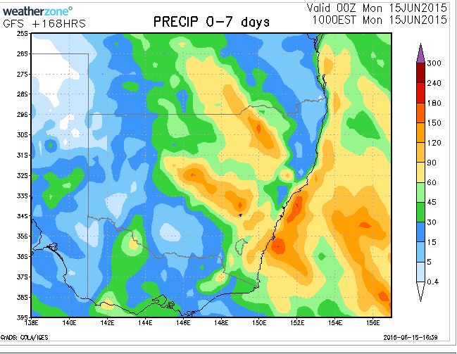
This system is tracking further east and the attached updated rain model (GFS dated 15/6/15) suggests some extensive rainfall across the Central West and North West slopes of the state. Based on the updated model this would suggest rainfall of upwards of 50 to 60 mm for towns such as Dubbo, Forbes and Parkes (Central West). This would also suggest strong rainfall totals of upwards of 90 mm around Inverell, Moree and Narrabri (North west slopes and plains).
The model also suggest falls of at least 30 mm or more around Sydney and lighter falls across the South West slopes. This would imply places like Albury and Wagga receiving at least 15 to 30 mm.
The attached model is updated from that used in the earlier post concerning the topic.
Alice Springs hailstorm - On a similar matter, this system produced an unusual hailstorm across Alice Springs although it appears the worst of the storm missed the main weather station for the town given that only 2 mm of rain was recorded at the weather station. It is unknown how much rain fell elsewhere.