 Looks like there is potential for some significant weather this week. Could be either a cold weather outbreak or even possibly a severe storm outbreak depending on timing and the return of moisture. Im very excited as either way the models are showing a significant upper low wed/thurs with temps as cold as -28 in Qld!
27 thought on “Looks like there is potential for some significant… October 11 and 12”
Leave a Reply
You must be logged in to post a comment.
Like the other format better!
Wow I must say if it goes off – that is an incredible event for this time of the year – more like a mid-winter pattern! And then an East Coast Low to follow with some useful rainfall to fight those bushfires.
you mean the one now or the one with the green banner on top?
this one now, much easier o use, cleaner and less clutter and I like the idea of posting a status update instead of a full news thread.
So what is the latest Jeff – are the models still excited about this system. I have not checked this morning.
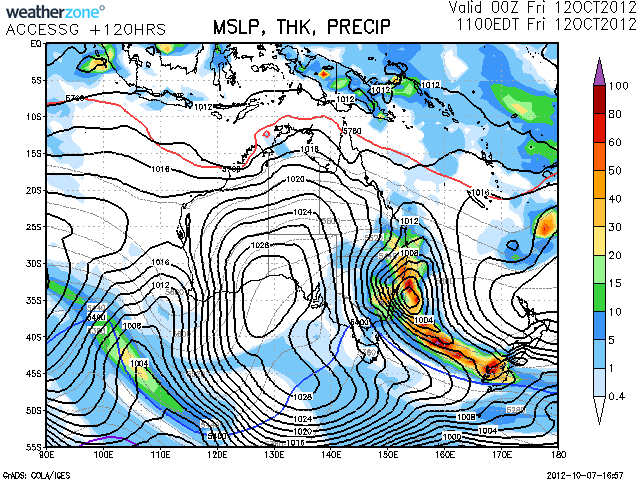
Given the system is cradled between two high pressure systems, it may not be in hurry to exit the region.
I look forward to this :D
Could even produce some snow for the NSW NTs though I've seen every event downgrade this year. BoM for Friday has "Partly cloudy. Isolated showers in the morning and afternoon, falling as snow above 900 metres. "
These sort of systems tend to produce some snow in the precip band even when temps are little high than what you'd normally need for snow.
The latest models I checked this morning still pointing towards this cold outbreak and about 20 to 30mm of rain to fall along the east coast perhaps more further north which is excellent. The models keep alternating the positioning if the coldest air but in the end it will gradually pass across the ranges.
Pero what component are you favoring, the rain or snow?
id have to say both on that one :D too exciting love to see the results
The models seem to be consistent with 20 to 50 mm although the GFS suggests an area around Wollongong to have more. The BOM model suggests anywhere from Sydney southwards along the NSW coast to collect 25 to 50 mm Friday.
As much as I want to see snow, I want to see super cells more. I really hope that a surface low develops inland Wednesday night and severe storms initiate along the slopes, tablelands and coast.
I guess it was not a downgrade! With dew points of 3 C it was more than sufficient for snow. And then even Goulburn copped some snow.
Like the other format better!
you mean the one now or the one with the green banner on top?
this one now, much easier o use, cleaner and less clutter and I like the idea of posting a status update instead of a full news thread.
So what is the latest Jeff – are the models still excited about this system. I have not checked this morning.
Given the system is cradled between two high pressure systems, it may not be in hurry to exit the region.
I look forward to this :D
Pero what component are you favoring, the rain or snow?
id have to say both on that one :D too exciting love to see the results
Could even produce some snow for the NSW NTs though I’ve seen every event downgrade this year. BoM for Friday has “Partly cloudy. Isolated showers in the morning and afternoon, falling as snow above 900 metres. ”
These sort of systems tend to produce some snow in the precip band even when temps are little high than what you’d normally need for snow.
I guess it was not a downgrade! With dew points of 3 C it was more than sufficient for snow. And then even Goulburn copped some snow.
The latest models I checked this morning still pointing towards this cold outbreak and about 20 to 30mm of rain to fall along the east coast perhaps more further north which is excellent. The models keep alternating the positioning if the coldest air but in the end it will gradually pass across the ranges.
The models seem to be consistent with 20 to 50 mm although the GFS suggests an area around Wollongong to have more. The BOM model suggests anywhere from Sydney southwards along the NSW coast to collect 25 to 50 mm Friday.
As much as I want to see snow, I want to see super cells more. I really hope that a surface low develops inland Wednesday night and severe storms initiate along the slopes, tablelands and coast.