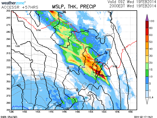
If meteorological models are correct, they have been consistent in placing a rain event on Wednesday with the possibility of some heavy falls. A low pressure system and associated upper trough and instability should combine with deep moisture to produce some heavy falls of rain across parts of central eastern NSW. Thunderstorms may develop during the afternoon and evening maximising the rain event during this period. Local flooding may occur if the predicted falls of up to or exceeding 100mm occurs but it remains to be seen if this occurs. This system will be monitored closely.


Meanwhile, the past 24 hours produced reasonable widespread falls yesterday until 9am this morning before the main cloud band cleared to the north east of the state.
Notwithstanding the rain plots provided for the 24 hours to 9 am 17/2/2014 it is identified that rainfall across Sydney varied from 7.2 mm near Macquarie Fields to 41 mm at Hornsby.
Generally rainfall across Sydney varied according to regions. Generally, rainfall varied from 11 mm to 26 mm across the south and west of Sydney to 20 to 41 mm across the northern suburbs of the city.
It was interesting to see the rainfalls increase with heavier showers / rain following the passage of the southerly change.
Further away from Sydney, the Hunter region did well to score 25 to 45 mm but very localised falls of 57 mm and 60 mm occurred at Upper Chichester and Barrington. Good falls occurred around the Central Coast as well.
On the north coast of New South Wales, a very small area within the Bellinger Valley received 61 mm to 66 mm. This includes localities or small towns such as Bowraville – 61 mm, Taylors Arm – 63 mm, Bowra Sugarloaf – 65 mm and Girralong 66 mm.
Rainfall was lighter across the north west slopes of New South Wales with falls of 6 to 22 mm being common. Further north towards Moree, rainfall became too light and patchy to have any impact on the big dry. Falls varied from 1 to 9 mm.
There was a fall of 26 mm at Brewarrina and a good fall at Bourke as well.
Even in todays Daily Telegraph (Page 4 and 5), it is suggested that the rain was too little in many places to have much impact on the dry and the big totals were indeed patchy or isolated in nature. A few places have received relief from the dry but it is identified that follow up rain is needed especially across the north of the state where the drought is at its worst.
Further to Wednesday afternoon, it seems according to the Access Models that there is follow up rain during the afternoon affecting Sydney, Blue Mountains and areas further north with some solid totals suggested. The Access Model does not show much falling to the south and west of the state with that area remaining mostly dry or drier. This could be one to watch.