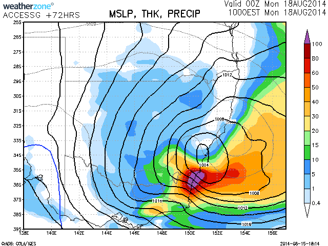
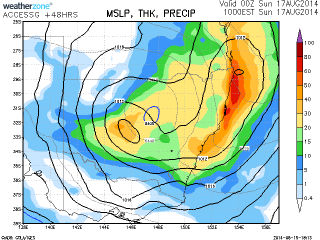
Heavy Rain and an eventual east coast low is expected on the Illawarra to South Coast over the coming days. Some intense wind and rain conditions can be anticipated locally. Rain should develop from where it has already been raining over the northern inland areas of NSW and spread south during Saturday. Rain should increase during the day or perhaps afternoon. Most of the intense activity should be Sunday with thunderstorms possible and also an intensification in the low pressure system off the coast as the cold pool and associated upper trough destabilises the atmosphere along the coast.
Whatever happens, this is undoubtfully looking ideal for the best rainfall for NSW in months with mostly rainfall totals of about 20 to 40mm with some nearing 100mm possible in isolated pockets! Drought stricken areas of NSW will at least see some positive rains!
Great rains on the way! Awesome!
Great rains on the way! Awesome!
Wow! Some excellent rains have occurred right across regions of NSW and still falling as we speak. Harley Pearman may wish to update us with the stats over the coming day or so. Even SE Queensland was meant to get rains! Great to wake up to heavy overcast and easterly winds with light rain than the day after day of dry weather. Almost forgot what rain looked like there for a while!
Wow! Some excellent rains have occurred right across regions of NSW and still falling as we speak. Harley Pearman may wish to update us with the stats over the coming day or so. Even SE Queensland was meant to get rains! Great to wake up to heavy overcast and easterly winds with light rain than the day after day of dry weather. Almost forgot what rain looked like there for a while!
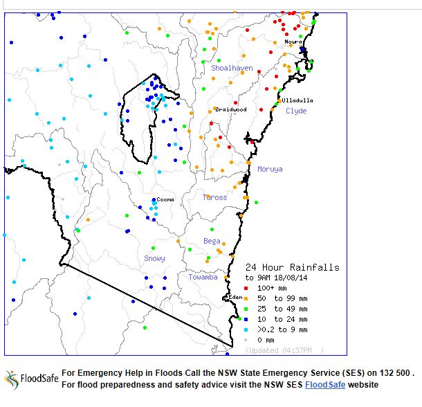
I have looked at Sydneys rainfall for this event. For the 24 hours till 9 am 17/8/2014, the following rainfall occurred:-
43 mm at Sutherland.
38 mm at Penrith.
37 mm at Randwick.
34 mm at Mona Vale.
30 mm at Hornsby.
They are generally the highest totals across the city. There are no outstanding falls during the period across the city.
Generally around Western Sydney of Blacktown to Parramatta, falls were more moderate at between 18 mm and 24 mm.
I was watching the weather closely at around dusk Saturday night and noted how quickly the rain system enveloped much of Sydney. There was a period of moderate rain at Blacktown between 7 pm and 8 pm before it eased off to lighter rainfall.
After 9 am up until 4 pm 17/8/2014, some heavier falls were concentrated across South Western Sydney with an isolated fall of 53 mm at Camden and 43 mm at Prospect Dam. Bringelly received 39 mm and Liverpool 33 mm. Falls were much lighter elsewhere across the city.
Rainfall has now become concentrated on the New South Wales South Coast especially on the southern side of the low pressure cell. The south coast around Nowra, Ulludulla and Batemans Bay should be watched to see what occurs here.
This system did produce good rainfall across the far west New South Wales on Friday including 32 mm and 6 mm respetively at Tibooburra and 23 mm at Broken Hill.
There are some substantial falls across south eastern Queensland but I have not looked at these in any detail at this stage.
Thanks Harley Pearman for posting the rainfall statistics on http://www.extremestorms.com.au/heavy-rain-event-east-coast-low-16th-17th-august-2014/ – interesting that Camden and some of the SW suburbs also copped some more rain. Question is – did the nearby ranges also cop some rain?
Thanks Harley Pearman for posting the rainfall statistics on http://www.extremestorms.com.au/heavy-rain-event-east-coast-low-16th-17th-august-2014/ – interesting that Camden and some of the SW suburbs also copped some more rain. Question is – did the nearby ranges also cop some decent rain? Models initially had the region west of Camden into the Blue Mountains to top 100mm.
I have had a greater look as to what occurred. It is identified that the whole east coast south of Gladstone received the good falls and yes some did penetrate into the ranges.
It is identified that the south west slopes of New South Wales and Riverina largely missed out on any rainfall. Off course this system did not penetrate much into Victoria although it is understood that Gippsland should receive a soaking.
The falls are widespread along the eastern seaboard but there are no true outstanding totals and the best totals barely reached 100 mm. The 100 mm totals are highly isolated. The following is identified for the 24 hours till 9 am 17/8/2014:-
Wollongong 50 to 74 mm. Falls are fairly uniform across the Wollongong region. Rixons Pass had 74 mm being the highest total.
North Coast:- Falls are highly widespread but uniform. The best total occurred at Lowanna 77 mm, Fishermans Reach 74 mm and Nambucca Heads 68 mm. There are many ststaions with 40 to 50 mm being recorded for the period.
Tweed:- Falls of 50 mm to 76 mm were common. There was an isolated fall of 107 mm at Lake Ainsworth and another isolated fall of 118 mm at Ballina Airport.
The trend is an event showing consistent falls right along the coast and adjacent ranges.
Queensland
Gold Coast:- 50 to 107 mm with the highest totals being at Carbrook Alert 107 mm, Pacific Pines Alert 105 mm, 103 mm at Springbrook Alert and Oxenford 101 mm. A closer look shows consistent totals of 54 to 99 mm except for the stations that recorded 100 mm.
Brisbane:- The range is from 11 mm at Marbing Alert to 107 mm at Carbrook Alert (Mentioned above). The city centre region received 55 to 61 mm and much of Brisbane itself had in excess of 35 mm.
Further north to Gladstone:- Falls of 25 to 50 mm feature although there is an isolated fall of 120 mm at Bucca Weir which seems to be the highest total of any rain guage that I can find.
Some strong rainfall across Sydney for the 24 hours till 9 am 18/8/2014. They include:-
58 mm at Bankstown.
62 mm at Woodville Golf Club.
62 mm at Prospect Dam.
64 mm at Bringelly.
68 mm around Ermington.
78 mm around Camden.
Where I live, 34 mm was common for the period.
Interestingly, the heavier falls are concentrated into south west Sydney. What makes this unusual is that 8 to 10 mm fell around Sydneys northern beaches being 8 mm at Avalon Beach and 8.5 mm around Mona Vale.
This morning heavy rain commenced between 6 am and 7 am and totals rapidly increased between 7 am and 9 am, especially across southern and south west Sydney.
Another feature is the maximum daytime temperatures are below average. This August is shaping up to be completely different to the August of 2013.
Cumulative totals are now substantial for some areas such as 108 mm at Camden for the 48 hour period 9 am Saturday to 9 am Monday. Nearby Ingleburn had 99 mm for the same period. Where I live in comparison, 55 mm had fallen for the 48 hour period. Probably the lowest figure is around Mona Vale on 42 mm for the same period.
A significant portion of the New South Wales south coast has been inundated with heavy rain for the 24 hour period 9 am Sunday morning to 9 am Monday period.
The wettest area lies from Batemans Bay to southern Wollongong and west to the coastal ranges. Topography has played a role. The bigger totals include:-
Yalwal 102 mm.
Batemans Bay 103 mm.
Majors Creek 104 mm.
Araluen 112 mm.
Jerrawongala 117 mm.
Moruya (The Lagoon) 135 mm.
Brooman 141 mm.
Mangarlowe 169 mm.
Sassafras 173 mm.
Porters Creek Dam 195 mm.
Closer to the Illawarra region:-
Hampden Bridge 142 mm.
Robertson 146 mm.
Fitzroy Falls locality 154 to 156 mm.
Wattamolla 156 mm.
Brogers Creek 2 179 mm.
Beaumont 181 mm.
Substantial falls penetrated into the Goulburn region where 60 to 67 mm fell.
Many of the places mentioned are localities and not towns but there are enough rain guages to show what has been occurring.
Overnight, the heavy rain continued for much of Sydney with a swathe of suburbs west and north of the Sydney CBD but east of Blacktown certainly receiving a soaking. The heaviest falls are concentrated around Parramatta, Homebush Bay, Bankstown, Auburn, Chatswood and Hornsby. The totals up until 9 am 19/8/2014 include:-
77 to 92 mm around Hornsby and Waitara.
56 to 61 mm within the vicinity of Chatswood.
66 mm around Auburn and Lidcombe but increasing to 67 and 73 mm around Sydney Olympic Park and Silverwater.
66 mm around Merrylands West.
51 to 87 mm around Baulkham Hills and Castle Hill.
Blacktown was on the western edge of the heaviest falls with 28 mm to 37 mm falling and 46 mm falling near Parklea.
Areas to the west received much less being 9.6 mm at Penrith, 9.2 mm at Camden and 7 mm at North Richmond. Interestingly La Peruse received 17 mm and Bondi received 23 mm.
Driving to work this morning rather early, I drove into heavy rain at Parramatta with much water across roads at times from the rainfall.
It is the cumulative totals that are of interest and should be noted for Sydney. For selected weather stations, I have tallied the rainfall for the 3 days from 9 am 16/8/2014 to 9 am 19/8/2014. Some of the figures are reasonable as follows:-
North Richmond:- 51 mm.
Penrith:- 65.6 mm.
La Peruse:- 68 mm.
Bondi:- 77 mm.
Mona Vale:- 86 mm.
Observatory Hill:- 89 mm.
Blacktown:- 91 mm.
Parramatta:- 93 mm.
Parklea:- 101 mm.
Cronulla:- 105 mm.
Glenorie:- 110 mm.
Camden:- 117.2 mm.
Bankstwon:- 127 mm
Hornsby:- 138 mm.
Merrylands West:- 148 mm.
Gordon:- 159 mm.
This provides some idea what has occurred across Sydney during the three days. Conditions seem to be easing now with lighter showers as the system causing this moves away from the coastline.