Thunderstorms on Saturday 6 December including a heavy rain event produced significant rainfall totals across parts of the New South Wales Coast. Due to a number of storm chases being undertaken at the time, I had little time to download some rainfall plots. However, the following rainfall totals from the Saturday event should be documented in this post to ensure there is some record of what occurred.
New south wales South Coast
Moruya (Plumwood) - 257 mm.
Moruya (The Lagoon) - 200 mm.
Bettowynd (Nobbys Hill) - 194 mm
Angledale - 174 mm.
Araleun - 148 mm.
Perisha Valley - 128 mm.
Bemboka - 127 mm.
Bega - 126 mm.
By far, the heaviest falls fell on the New South Wales South Coast.
Another rain event including storms and general heavy rain pushed up rainfall totals across Sydney to significant levels including:-
Maroota - 81 mm.
Clarence and Penrith - 50 mm.
Kings Langley 48 mm.
Badgereys Creek - 44 mm.
Auburn - 42 mm.
Some of the big totals came from storm events. I chased with Jimmy on this day which saw us eventually drive to Wellington - Central West New South where we intercepted one of these storm / rain events and drove back to Sydney with it. Driving back at times was difficult due to the heavy rain. The rain was particularly heavy south of Wellington, east of Orange and again crossing the Blue Mountains and at times some great lightning strikes were observed especially the one we saw at Bathurst and Lithgow. That saw us to forego dinner and continue to Lithgow and eventually back to Richmond.
I just want to thank Jimmy for assisting with the driving as that was helpful. The level of rain encountered was tiring and draining which made me tired requiring a break. I also wish to thank Jimmy for the great pizza at Richmond.
I noted the lightning and strobing effect waned once the evening rain band reached the lower Blue Mountains. It seemed to cross Sydney as a rain band.
I will document the actual storm chase below so the chase is not confused with this part of the post.
While the rainfall event was unfolding, Jimmy and I undertook a full day storm chase which saw us first drive to Bell where we intercepted a developing storm with an interesting base. We drove back and forth to obtain the best viewing locations of the storm including the base.
As it was we found a hail event but the hail was small only to pea size.
Please find attached a photo below of the first storm of the day on the Blue Mountains intercepted east of Lithgow and near Bell.
Following this, we then went further west to the Bathurst region to view developing storms. This became problematic because it seemed that too many cells were competing for space and the region became clustered with showers and weak storm cells.
We let the shower / storm complex go because it soon became clear that nothing substantial was going to occur other than showers and the occasional rumble of thunder.
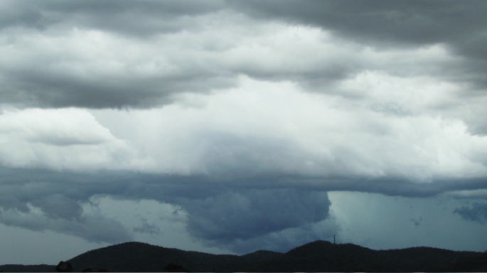
The image below shows a cell to our north which took our interest for a while.
After leaving Bathurst and driving further west to Orange, we passed underneath developing cumulo congestus clouds, a few with glaciated tops with sunlight penetrating between them but they were only dropping moderate to heavy showers and they were relatively brief.
When driving on the Orange Bypass north of town, we intercepted this cell which had some interest with a base. This produced a heavy shower and a burst of wind.
Beyond this, a period of sunlight ensured which enabled some heating.
In this regard, we had to go west of Orange to find some suitable heating ahead of another band of rain and storms. We also noted a wind change to the south west after this storm / shower at Orange. We went north towards Wellington.
Arriving at Wellington to fill up with fuel, we went north of town to intercept the storms coming from south of Dubbo.
For a period, the storm coming in from the west was interesting with a base that had a green tinge. There were soon other storm cells around us.
It was certainly warmer here following some earlier heating but as the case earlier on, a cluster of storms seemed to crowd the region and soon we were surrounded by storm cells. A few good cloud to ground lightning strikes were observed for a period from a nearby northern storm cell.
The photos show the base of the storm at Wellington which was the highlight for me for the day.
Following this, we attempted to get a hail dump because the base of the cloud showed a green tinge but it seemed to dump to our west with no roads. The daytime chase ended south of Wellington and it was game over. We returned to Sydney as heavy rain descended across the region.
I tallied the trip and we drove 737 km to document the storms for the day. In conclusion, it would have been better if there were less storm cells competing for space and less cloud cover.