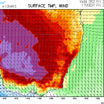

Models are consistent in forecasting heat wave conditions with brief respites along the coastal regions. Temperatures are nearing and exceeding 40C with the highest temperatures in western NSW and Victoria.
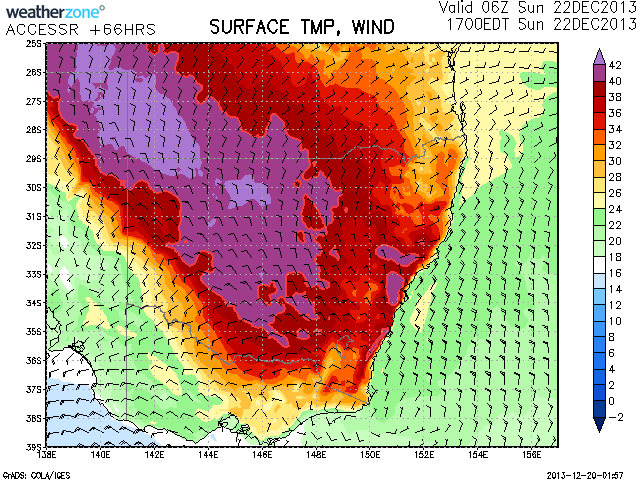
For Sydney, the highest temperatures are expected on Sunday with both 03Z and 06Z (2pm and 5pm respectively). The Riverina is in a region where temperatures will be in the above 40C range for several days.
Western Sydney sweltered overnight with uncomfortable conditions as temperatures hovered mostly around the 25C. Interestingly once again, burst of heat with temperatures rising to about 27C about 3am at Richmond was observed! And it seems more heat is on the way and I will be interested in the conditions overnight Sunday.
Further to the earlier posts, this is quite a serious heatwave leading into Christmas. It started in Western Australia then moved east. By Friday 20/12/2013, maximum temperatures did breach 40C across Western Sydney for the first time this summer although it was cooler across the coastal suburbs. This lead to an uncomfortable night.
A quick look at the weather station at Prospect Reservoir (Blacktown) revealed that it was still 30C at 10 pm and temperature dropped to 27.7C at 2.30 am Saturday morning. A cooler SE change eventually dropped it to a minimum of 21.7.
Late Friday evening, I was watching some lightning from a weak distant storm well to the NE but it was too far away for me to hear any thunder from it.
The cool change is creating interesting weather conditions across coastal NSW and inland NSW for much of Saturday. It is a weak change that has not generated much coastal cloud for Sydney. It has reached 31.9C at Penrith and 26.9C at Sydney Observatory Hill at 2.30 pm. At Orange Airport in comparison (Elevation 947 metres above sea level – Central Tablelands of NSW), the maximum temperature for Saturday reached 33.7C which is 6.8C warmer than Sydney Observatory Hill. Hot dry NW winds feature as opposed to cool maritime SE winds. Meanwhile at Bathurst Airport at 744.5 metres in elevation, it reached 36.4C as hot dry NW winds feature there as well. The cool change has not penetrated very far inland.
The heatwave is generally more of an inland weather feature. I have looked at some weather stations where the heatwave is at its worst showing maximum temperatures and some minimum temperatures where appropriate as follows:-
Albury Airport
Wed 18 Dec – 37.6C, Thu 19 Dec – 39.7C, Fri 20 Dec – 40.7C, Sat 21 Dec – 40C (When checked).
Griffith (NSW)
Tue 17 Dec – 36.1C, Wed 18 Dec – 39C, Thu 19 Dec – 40.8C, Fri 20 Dec – 41.9C, Sat 21 Dec – 41.7C (When checked). It has reached 40C on 3 days in a row.
Hay (NSW)
Tue 17 Dec – 36.7C, Wed 18 Dec – 40.7C, Thu 19 Dec – 41.9C, Fri 20 Dec – 42.7C, Sat 21 Dec – 43.4C (When checked). A feature here is 4 days in a row of plus 40C temperatures. Of interest is an overnight minimum of 28C Friday morning.
Ivanhoe (NSW)
Tue 17 Dec – 38.6C, Wed 18 Dec – 41.3C, Thu 19 Dec – 42.1C, Fri 20 Dec – 42.4C, Sat 21 Dec – 43.2C (When checked). A feature here is 5 days in a row of plus 38C including 4 days in a row of plus 40C temperatures and three days in a row of plus 42C temperatures.
The overnight minimums are remarkable too being 19.2C (17 Dec), 21.7C (18 Dec), 27.6C (19 Dec), 27.7C (20 Dec) and 27.6C (21 Dec). This means that the overnight minimum at Ivanhoe has not dropped below 27C for three nights in a row between 19 December and 21 December..
Wagga Wagga
Wed 18 Dec – 37.7C, Thu 19 Dec 39.6C, Fri 20 Dec – 40.5C, Sat 21 Dec – 40.2C (When checked).
Yarrawonga
Tue 17 Dec – 35.8C, Wed 18 Dec – 39.3C, Thu 19 Dec – 41.7C, Fri 20 Dec – 42.3C, Sat 21 Dec – 39.9C (When checked).
I will provide further details as the hot conditions persist.
Further to the above, the heatwave ended on Monday 23 December. Across Eastern Australia, the heatwave was at its strongest across the Riverina, weatern plains, south west slopes (New South Wales), Northern Country, Mallee and Wimmeria of Victoria and off course the outback. This was followed by a cool change that brought a rain band across the south of NSW and Victoria on Monday that brough some useful rainfall.
For Sydney and especially the west, there were two heat bursts interspersed with a weak SE change.
For the five selected places in the study, the following maximum temperatures occurred. Some significant minimum temperatures are included:
Albury – Sat 21/12 – 40.5C (Min 23.7C), Sun 22/12 – 36.4C (Min 25.2C), Mon 23/12 – 23.3C. A rainband on Monday brought 18.2mm of rain being a sharp contrast to the hot weather.
Hay – Sat 21/12 – 43.1C, Sun 22/12 – 38.4C, Mon 23/12 – 22C. Light patchy rain on Monday brought 11.2 mm to the region.
The region experienced at least 4 days of 40C maximum temperatures.
Ivanhoe – Sat 21/12 – 43.2c (Min 27.6C), Sun 22/12 – 40.1C (Min 29.5C), Mon 23/12 – 23 to 25C. Cloud brought a few showers to region and only 1.2 mm of rain.
Griffith – Sat 21/12 – 43.1C, Sun 22/12 – 40C (Min 25.7C), Mon 23/12 – 18C. Cloud and light rain / showers brought 2.6 mm of rain to region.
Wagga Wagga – Sat 21/12 – 41.4C (Min 23.4C), Sun 22/12 – 41.2C (Min 21.8C), Mon 23/12 – 20 to 21C. Cloud brought 4.6 mm of rain across region.
The cloud and rain across the region was enough to end the heatwave.
Western Sydney
On Sunday it reached 40.2C around Blacktown / Prospect which is a second 40C temperature for December. When analysing temperature data, it was still 30.3C at 11.30 pm (Late Sunday night) and 27.1C at 3 am early Monday morning making it very uncomfortable for sleeping. There was some cooling thereafter to a low of 22.5C. Monday it reached 35.9C before the cool SE change took hold during the latter part of the afternoon.
Campbelltown it reached a high of 39.8C on Sunday, 40.6C on Friday with a 30C day on Saturday.
Richmond had 40C Friday, 30.9C on Saturday but only 37.1C on Sunday and 36C on Monday.
Penrith had a high of 40.5C on Sunday. A big feature here was that it was only 30.5C at 11.30 am but it took till 3 pm to reach 40C. (A late 40C reading). It remained at 40C till 5 pm. It was still 31C at 10.30 pm. The daily temperature was above 30C for 11 hours. The heat built slowly but dissipated slowly. The minimum temperature cooled to 23.4C by 6 am (Source BOM Weather observation for Penrith Station Details ID 067113 (23/12/2013).