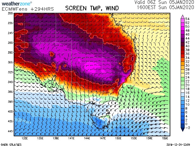
Ok this is worthy of discussion and not the type of news we wanted for the bushfires!. Yes we have to be very careful this far off with models chopping and changing but take a look at the predicted temperatures at 5pm on the 5th January 2020! At first my mind was centred on the inland! Then I took a look a the coast near Sydney. Am I seeing correctly with the pink shading? 48 to 49C in Sydney region.
Yes I know this is a gossip horse and it will take the intensification of the baking inland trough and timing as well as positioning for western Sydney to achieve this as a record smashing event! AGAIN approach with caution as this is way out on EC 15 Day models. But still a point in discussion.
GFS is also showing 40C temperatures at 11am for the same day! For the US counterparts - 48C - 118.4 49C - 120.2
Please note there is a dangerous fire period likely and consistent with all models between December 27th to December 31st 2019. But if this verifies this should obviously be labelled catastrophic fire danger level!


-
Jimmy Deguara Matthew Piper is referring to this the latest from the same model which runs 4 times a day and the same model picks up extreme temperatures.- again a reminder with all the shares that this may be hype and it is only a discussion about how and why models (perhaps it may eventuate) are picking an extreme heat event. If it verifies attacking the record set in 1939.
-
Jimmy Deguara The GFS has the heat wave maximised on the 4th January - and the southerly coming through on the 5th. The timing of the southerly is critical in this event being realised - I guess a worst case scenario.By the GFS model at this time frame ahead has only 11am available to indicate heating earlier in the day - 3pm to 5pm is the maximum heating period on most of these January events!

-
Jimmy Deguara Sadly after all these analyses, unfortunately there are little signs of significant rainfall for the Sydney region or for any west and south of Sydney areas until dreamland the 9th January 2020. That's at least another 2 weeks of drying with heat and wind increasing the fire danger levels with successive heat waves!


If that verifies … can’t even begin to imagine. :(
wow!!! wildlife on the east of the divide will not cope with 50c. they will drop dead everywhere
That is a scary map Jimmy.Obviously being so far out,things will change but as you say its worthy of a discussion .
Thankfully last Saturday was a flop in Western Sydney with the hottest of the airmass never quite reaching the basin. 42 is still hot, but light years away from the potential 47 on that day,had the proper hot airmass reached the basin. You only have to look at Nowras 45.6 though to see the potential,,and west Sydney is often 2c hotter than Nowra on those really hot days.
As for the upcoming scenario, it appears the very hot airmass is out there, just need the right ingredients to transport it here . I hope it doesent come off, and some how we get spared, but there is no question somewhere is goong to bake.Obviously we have to get through a catastrophic fire day early next week first, an event that may bring the Currowan bushfire to Nowras doorstep.
The winds aren’t too outrageous thankfully though in those temps the fires can become fairly independent and generate its own inflow with enough fuel.
Dan StewStew
Let’s hope not.
I hope that doesn’t happen. You guys need a break.
Jeez…
This has been worrying me, if correct we will have several nights of pre warming and low humidity. Reminds me of of Jan 1994 and Dec 2001
Glenn Winters
Clint Hawking here it comes
That is a hell of a long way out, it is disconcerting to see, if it holds true between now and next week. Not often we see a model hold for that long. Could go either way.
Brett Tiyce
Dale Tiyce
Allison Hawking
A very worrying possibility ?? The latest run of the EC ensemble is sticking with this scenario and the regular EC is also starting to show it approaching on the 4th January. There is a glimmer of hope though that once this period is over the monsoon will start to make its presence felt.
Robyn Betts
Jo Betts
Kyle Tiyce
Kelsie Tiyce
Matthew Piper is referring to this the latest from the same model which runs 4 times a day and the same model picks up extreme temperatures.- again a reminder with all the shares that this may be hype and it is only a discussion about how and why models (perhaps it may eventuate) are picking an extreme heat event. If it verifies attacking the record set in 1939.
The GFS has the heat wave maximised on the 4th January – and the southerly coming through on the 5th. The timing of the southerly is critical in this event being realised – I guess a worst case scenario.By the GFS model at this time frame ahead has only 11am available to indicate heating earlier in the day – 3pm to 5pm is the maximum heating period on most of these January events!
Sadly after all these analyses, unfortunately there are little signs of significant rainfall for the Sydney region or for any west and south of Sydney areas until dreamland the 9th January 2020. That’s at least another 2 weeks of drying with heat and wind increasing the fire danger levels with successive heat waves!
Thanks for the Xmas cheer!