The period 25 to 28 January 2015 will be remembered for a number of weather extremes at either end of the scale across Eastern New South Wales including Sydney.
In particular, no less than 6 or 7 varying weather events have occurred during this period in such a short time. They include:-
1 - A significant morning fog Sunday morning across parts of Western Sydney which for me, is the first time I have seen a major fog occur mid summer in mid January. The fog had burnt off prior to 8 am Sunday.
2 - A hot day across Sydney Sunday. The fog across Penrith quickly burnt off only to have maximum temperatures soar to 36C or 37C across large areas of Sydney on the same day. It is determined that this was the second or third hottest day of the summer depending on suburb or location.
3 - Thunderstorms although isolated in nature just to the north of Sydney during late Sunday.
4 - A southerly buster moving north along the New South Wales South Coast late Sunday which was just strong enough to be classified as a true southerly buster. It brought winds to 61 km/h at Albion Park.
5 - Three days of rain that brought significant rainfalls from the 26 to 28 January as well as unusually cool conditions for Australia Day 26 January and Tuesday 27 January in which temperatures struggled to reach 20C across much of Sydney.
This post will document the extremes of weather for that 4 day period because the variations are significant and remarkable and should be recorded.
I have attached a number of images to this discussion under each weather scenario that occurred.
Significant Event Number One
Sunday morning 25/1/2015, I drove to Penrith very early and I finished up documenting an unexpected morning fog. I later discovered that the temperature and dew points were around the 20 and 21C figure at Penrith. The morning fog was not minor but significant. The fact that this occurred mid summer makes it more unusual. I have never seen a fog occur in January in mid summer.
This occurred on a day when maximum temperatures were forecast to reach 35C across Western Sydney. I was fortunate enough to take a number of images from a bridge overpass at the University of Western Sydney near Penrith showing how dense the fog was including these in both directions.
Around 7.45 am, the sun broke through the fog and it had all but broken up around 8.30 am. There was no evidence of this event occurring after 8.30 am.
Significant event Number two
Sunday 25 January (And following the fog at Penrith), hot dry westerly winds saw temperatures rise rapidly to reach maximums well above the January average across Sydney.
Maximum temperatures include:-
Penrith – 36.7C.
Richmond – 36.3C.
Parramatta – 36.5C.
Prospect – 35.7C.
Sydney Observatory Hill – 34.4C.
This is either the second or third hottest day of the summer since 1/12/14. For Penrith and Richmond, this is only the third time the maximum temperature has reached more than 36C for the whole of summer with the highest being 37.3C on 4/1/15 (Penrith) and 37.7C on the 3/12/14 (Richmond).
The rise in temperatures came with the hot dry west north west winds which did turn more south west later during the afternoon.
Event Number three
Later Sunday, noticed a small thunderstorm cell develop just to the north of Sydney which moved off the coast ahead of the wind changes that were to occur. I observed two small storm towers. They struggled to gain much size and intensity but they show the contrast of weather that were occurring as the day progressed.
Significant Event Number Four
Later Sunday, a southerly buster moved north along the south coast bringing winds to 61 km/h at Albion Park (Shellharbour). This marked the big wind change and a dramatic change of weather.
Taken from Weatherzone – “Southerly buster cools NSW coast” (27/1/2015), a southerly buster must have winds reaching a threshold of 54 km/h and cause a temperature drop of at least 5C in three hours. While the southerly buster of Sunday night was not strong, it met the two criteria thresholds. At Albion Park after 5.30 pm, it lowered the temperature by 5C from 34C to 29C in nine minutes.
The southerly buster came through Sydney after 7 pm bringing a wind gust to 59 km/h and causing a 5C temperature drop in 30 minutes.
As a result, this wind change is classified as a southerly buster.
This brought the rapid onset of cloud and a significant weather change from heat to cold and rain that was to last Monday, Tuesday and much of Wednesday.
Significant Event Number Five – Unusually cool January conditions
Following the southerly buster of Sunday, Monday and Tuesday 26 and 27 January 2015 saw unusually cold conditions for January and summer with maximum temperatures significantly below average and a major contrast to Sunday.
These include for Sydney:-
Sydney – (Monday) 20.4C (Tuesday) 20.4C.
Prospect – (Monday) 20.2C (Tuesday) 19.2C.
Richmond – (Monday) 20.4C (Tuesday) 20.2C.
Penrith – (Monday) 20.7C (Tuesday) 19.4C.
Parramatta – (Monday) 21C (Tuesday) 19.8C.
This was common right across Sydney.
This may have been the coolest Australia Day for Sydney in around 50 years (Weatherzone 28/1/2015).
In addition, it is found that Canberra and Melbourne had their coolest Australia Day since 1998.
The such cool temperatures came with low cloud, drizzle to begin with then heavy rain / showers that saw many areas receive a drenching.
An east coast low developed of the New South Wales coast that progressed south. A warming trend commenced on Thursday for the coast as winds tended more south west and offshore rather than onshore.
Significant Event Six – Heavy coastal rain
Initially the rainfall that commenced Monday was not heavy but sustained drizzle, especially around Gosford to Sydney’s north where I was.
As Monday progressed, rainfall spread which continued through the 27/1/2015. By 9 am 27/1/2015, significant rainfall had occurred especially on the North Coast of New South Wales. Figures include:-
Bellingen (Crystal Creek) – 190 mm.
Port Macquarie – 166 mm.
North Bonville and Laurieton – 160 mm.
Pappinbarra – 149 mm.
Bowra Sugarloaf – 147 mm.
Wittitrin – 140 mm.
Here in Sydney some moderate to heavy falls also occurred including:-
Bondi – 59 mm.
Castle Cover – 58 mm.
Frenchs Forest – 57 mm.
Randwick – 50 mm.
Manly – 42 to 46 mm at the recording stations.
There were lighter falls across Western Sydney. I attached the plots showing this for the 27/1/2015.
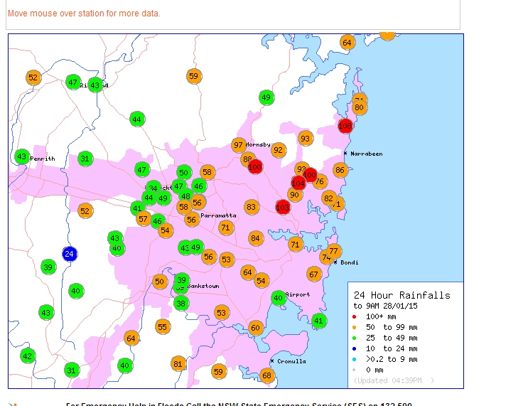
By the 28/1/2015, the focus of the heavy rain shifted to Sydney and the Central Coast with some falls reaching 100 mm for the 24 hour period. These include:-
Mona Vale – 108 mm (Highest total).
Forestville – 104 mm.
Chatswood – 103 mm.
Frenchs Forest and Turramurra – 100 mm.
As a contrast, only 24 mm fell at South Creek at Elizabeth Drive being the lowest across the Sydney region.
Central Coast
Hamlyn Terrace Public School – 147 mm (The highest).
Whiteman Ridge – 128 mm.
Gears (Wyong River) – 124 mm.
The Entrance – 113 mm.
Kangy Angy – 110 mm.
Avoca Reservoir – 108 mm.
The rainfall tapered off during Wednesday with Sydney having much lower rainfall for the 24 hour period to 9 am 29/1/2015. The rainfall range fell between 5 mm and 23 mm although a very isolated total of 30 mm fell where I live which is unusual (The highest total).
I attach the rainfall plot for Sydney for the period 28/1/2015.
Overall, the above is representative of a number of significant weather events experienced within the four day period.
Hi Harley when you think about it – yes there were significant changes during that late January period! One thing I am awaiting is whether we crack 40C by yhd DNS of February. If not, will this be the first summer ever where sprung held a higher maximum than all summer events for that season – ie 45C temperature!
Hi Harley when you think about it – yes there were significant changes during that late January period! One thing I am awaiting is whether we crack 40C by yhd DNS of February. If not, will this be the first summer ever where sprung held a higher maximum than all summer events for that season – ie 45C temperature!