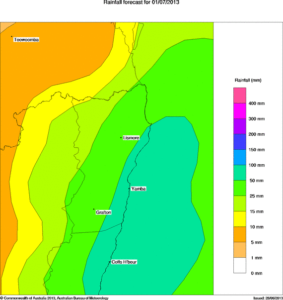
A strong upper trough will move into the region Sunday and help deepen in an existing surface trough along the coast. An East Coast Low is likely to form near the SE QLD coastline. The forecast position and intensity of this low varies between the weather models but the most likely outcome at this stage is for the Gold Coast, Northern Rivers and northern parts of the Mid North Coast to cop the worst of it - especially during Monday. Strong to gale force wind gusts may also develop along the coastal strip. Some locations may see falls of 150-200mm over 48 hours - though this looks much more likely for coastal areas.
Thunderstorms are possible in the mix as instability is present both Sunday and Monday - expect heavy rainfalls if you're under one of those.
Rain areas and showers should persist into Tuesday clearing from the north with Wednesday fining up. Then several days of clear skies are expected.
Attached is the rainfall forecast map from the BoM for Monday.
This event seems to follow on from the recent east coast low and models do show potential for heavy rain on the north coast.
This event will have some impact on Sydney but the focus of the heaviest falls appears to be the north coast. A feature of this event (At least the early stages) and the previous event is the number of days in a row where rain has fallen or likely to fall here in Sydney. Since moving to Blacktown in 1997, I cannot remember 8 days in a row where rain has fallen.
Here in Blacktown rainfall has not been heavy but it has been constant. If one was to review the Seven Hills weather Station which is the closest one to Blacktown since Sunday 22 June, the result is this:-
Sun – 17 mm, Mon – 26 mm, Tue – 6 mm, Wed – 15 mm, Thu – 4.4 mm, Fri 1 mm, Sat – 12 mm.
This comes to 81.4 mm on 7 days and there has been more rain from the latest rain event since 9 am 29/6/2013 making it 8 days in a row where rain has fallen. With showers forecast from the latest low for Sunday, this could make it 9 days in a row where rain has fallen where I live.
Interestingly, if the same exercise is done for Sydney Observatory Hill, rainfall has been heavier as follows:-
Sat – 1.2 mm, Sun 56.2 mm, Mon 53.4 mm, Tue – 5 mm, Wed – 15.6 mm, Thu – 0.8 mm, Fri 16.8 mm and Sat – 41 mm.
This comes to 190 mm on 8 days and there has been more rain from the latest event since 9 am 29/6/2013. Indeed, while much of Sydney received overnight rain, the heaviest falls were focussed close to the coastal suburbs where falls of 30 to 40 mm were common. By 9 am Sunday, Sydney city will have received rain on 9 days in a row and with showers forecast for Sunday, it is likely that it will rain on 10 consecutive days.
If one was to do this exercise for many other locations across Sydney, it would reveal 8 to 10 wet days in a row. in many areas across the city, especially towards the coast where the rain has been focussed and heaviest the most.
After 9 consecutive days when rainfall was recorded here at Blacktown and 10 such days across Eastern Sydney, dry sunny weather finally returned. However since my previous post on Saturday, large areas across eastern Sydney were again drenched. The heaviest fall to 9 am Sunday morning 30/6/2013 was 100 mm at Little bay near La Peruse followed by 84 mm at Narrabeen and 76 mm near Bondi.
The exceptional falls were confined to the coastal suburbs although areas 10 to 15 km inland from the coast received falls from 30 mm to 60 mm.
Further west, falls tapered to 12 to 25 mm around Parramatta but less than 10 mm around Blacktown tapering to just 3 mm at Windsor.
Throughout Sunday showers became less widespread across Western Sydney and some sunny breaks occurred over NW Sydney especially at Windsor where I was.
From Windsor, it was interesting to see the shower cells reach the coast but largely decay as they approached the area. A light shower did reach Windsor late in the day but generally far NW Sydney remained much drier.
For the 24 hours from 9 am Sunday to 9 am Monday, prior to the clearing trend, an isolated fall of 32 mm occurred at South Cronulla Bowling Club and 25 mm at Sancs Souci with very light falls elswhere. All of these occurred prior to daybreak. The first sunny day in 9 to 10 days ensured throughout Monday to allow some drying out.
However there has been a rain event across far North East New South Wales with the Richmond / Tweed region experiencing the most. Lighter falls reached Brisbane but the heaviest falls were focussed onto the Richmond Tweed region.
For the 24 hours from 9 am Sunday to 9 am Monday, the heaviest falls included 84 mm at Ballina and Nashua, 72 mm at Houghlahans Creek, 60 mm at Alstonville and 52 mm at Lismore. Falls of 25 mm to 49 mm were common across the Richmond / Tweed region. There have been further falls since 9 am across the region but by 6 pm, there were not as significant but that may change overnight.
To conclude this topic and rain event some significant but localised rainfall occurred over portions of the Richmond / Tweed region of New South Wales for the 24 hours to 9 am 2/7/2013. Weather conditions rapidly eased following this event and it appears that no significant flooding occurred. The heaviest rainfall totals for the period were:-
Goonengerry – 119 mm, Terang Creek – 113 mm, Huonbrook – 112 mm, Repentence – 109 mm, Bangalow Motel – 104 mm and Mullumbimby – 101 mm.
Areas adjacent to these localities received 50 to 99 mm including 96 mm at Myocum, 73 mm at Dunoon and 65 mm at Tweed Heads.
In South East Queensland, some isolated big totals for the same period included 144 mm at Running Creek, 111 mm at Springbrook and 107 mm at Oreillys Alert. There were no other places that experienced 100 mm of rainfall.
Nearby areas received lesser totals including 96 mm at Gordon Mine, 77 mm at Darlington Alert and 58 mm on the Gold Coast. On the Gold Coast, the coastal strip received the highest totals but falls tapered sharply away from the coast.
Parts of Brisbane received some useful totals but they were lighter being 26 mm to 49 mm for the coastal suburbs, 10 to 25 mm for the middle ring suburbs tapering to 10 mm for the western localities.
Following this event conditions have cleared.