
Had a very enjoyable storm chase with James Harris on Thursday 10 January 2013 into the QLD Darling Downs region. We started off near Killarney and watched cumulus bubble along a boundary slowly develop. A cell exploded just east of Warwick with massive billowing tops. Next to no lightning had been observed when a flang hit within 200 metres of us - then three more in quick succession - a nice way to kick off the storm action.
A lull in activity drew us further west into the main target area. Shear was forecast to increase into the late afternoon and sure enough an interesting line of activity developed from north of Goondiwindi.
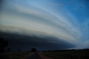
We enjoyed an amazing sunset lightning show near Millmerran then a spectacular shelf cloud formed and spread across the district.
Michael, awesome lightning pictures given the flat landscape and storm shelf cloud structure! Certainly makes the chase worth it. I gather this is one of your favourite areas for chasing!
Beautiful pics Michael, love the rugged cloud bases, and those sunset CGs are spectacular.
Yep, great areas there. Surprisingly the opportunity to chase there doesn’t come up too often for me. Bit too many trees in the southern Downs but if you draw a line west from Allora through Leyburn and west of there, it’s then mostly open fields and lots of roads to the north and northwest.
The photo with the shelf cloud and lightning coming out the left hand side reminds me of a US scene with Matt Piper in I think 22nd May 2002.
The photo with the shelf cloud and lightning coming out the left hand side reminds me of a US scene with Matt Piper in I think 22nd May 2002.