The system that produced the inland New South Wales and Victoria rain event of 17 and 18 April will continue to track east and cross the coast on Sunday. Weather models vary and it is still difficult to determine what will occur. However, it appears that a deep and wet south east air stream will develop Sunday and Monday and models are hinting of the development of an east coast low. The exact position is hard to determine at this early stage.
Models suggest the east coast low forming off the New South Wales mid north coast Monday then tracking south to be east of Sydney Tuesday and Wednesday before weakening in intensity.
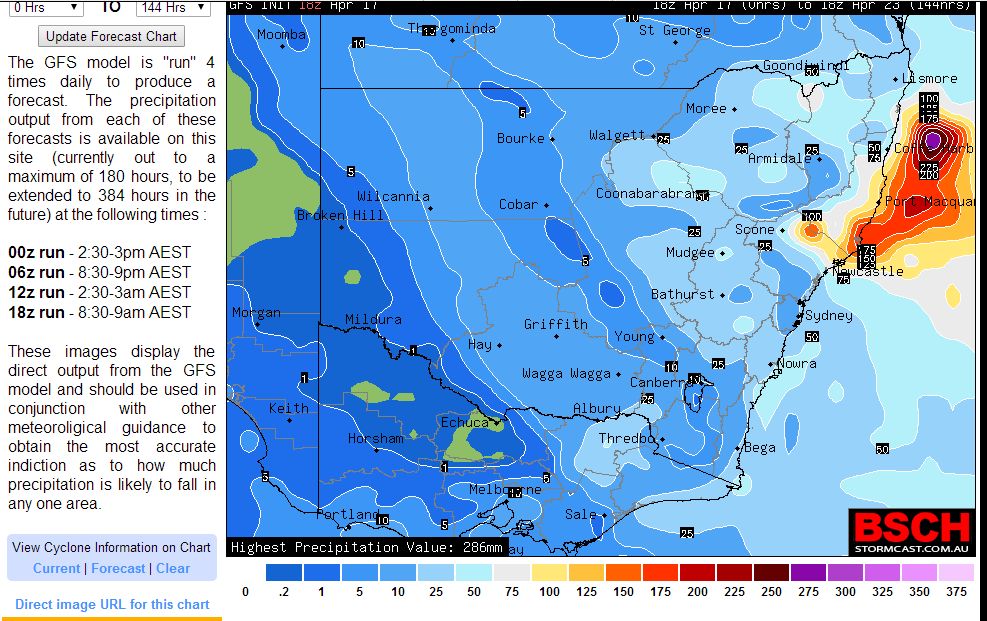
The GFS rain model attached is suggesting some heavy falls on the New South Wales Mid North Coast during this period. The Bureau of Meteorology model is hinting at possible falls of upwards of 200 mm during this period for the New South Wales mid north coast say Port Macquarie.
The problem with this rain model for Sydney is that it currently varies from the Bureau of Meteorology model. In this regard the Bureau of Meteorology model is suggesting rainfall upwards of 150 mm for Sydney during the period.
The Bureau of Meteorology model "Water and the Land" is hinting at heavy falls anywhere south of Port Macquarie all the way to the Victorian State Border but mainly coastal in nature during this period.
The exact location of who gets the heavy rain is determined by where the east coast low forms. Either way, a wet and windy week appears to be in store for the New South Wales east coast with the potential for a significant rain event.
http://www.extremestorms.com.au/coastal-rain-event-and-probable-east-coast-low-20-to-23-april-2015/
http://www.extremestorms.com.au/coastal-rain-event-and-probable-east-coast-low-20-to-23-april-2015/
http://www.extremestorms.com.au/coastal-rain-event-and-probable-east-coast-low-20-to-23-april-2015/
Interesting the forecast for Sydney for Monday based on Weatherzone is for rain and 40 to 80 mm. It is acknowledged that this is varying from what is posted in the plot above. While models are not consistent with how much rain falls and where it is generally accepted that some form of a rain event and probable east coast low is likely.
Interesting the forecast for Sydney for Monday based on Weatherzone is for rain and 40 to 80 mm. It is acknowledged that this is varying from what is posted in the plot above. While models are not consistent with how much rain falls and where it is generally accepted that some form of a rain event and probable east coast low is likely.
Interesting the forecast for Sydney for Monday based on Weatherzone is for rain and 40 to 80 mm. It is acknowledged that this is varying from what is posted in the plot above. While models are not consistent with how much rain falls and where it is generally accepted that some form of a rain event and probable east coast low is likely.
It appears that weather models are only now becoming more accurate as the date becomes closer. It appears that an east coast low will slowly develop Monday, intensify Tuesday off the New South Wales Lower to Mid North Coast then move southwards so that by Wednesday, the system would be east of Sydney.
Models seem to be more consistent with rainfall. It appears to be an intense low Tuesday to Thursday then weaken as it moves further south.
Please find attached a plot showing a probable or possible location of the system by Wednesday night from the GFS.
The amount of rain that falls in any given area is dependent on the position of the low. It appears based on models, anywhere north from Sydney to at least Kempsey is at risk from the bigger rainfall totals with the higher figures occurring from Newcastle to the mid north coast.
This system would produce typical east coast low weather conditions including strong to even gale force winds along and off the coast, rough seas and wet and even heavy rain.
Please find attached a rainfall plot prognosis from Weatherzone for the next seven days including this event.
Based on the plot, the area around Port Macquarie / Kempsey and Foster Tuncurry and areas inland of that region appear to be the region most at risk from the heaviest rain.