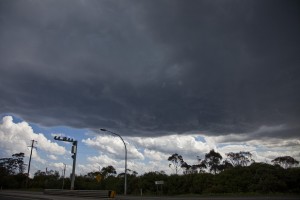
 With a change encroaching the Sydney region and Hunter, storms were anticipated over the Central Tablelands. Storms did fire and interacted with the boundary several times before becoming elevated.
Harley and I targeted the region near Lithgow with the prospect of heading towards Capertee and Ilford to Rhylestone area.
Storms fired on the Central Tablelands today.
A few more images from the several cells that passed over and developed typically in the Wollemi or Blow Mountains National Park.
Beautiful updraft over the Wollemi
And then the cell that passed over us at Blackheath. This cell went black on radar but just past Blackheath!
Another enjoyable chase with Jimmy. Initially after working through weather models, I had pinpointed two possible targets for the day being an area west of Singleton (Hunter Valley) or Lithgow to Capertee towards Mudgee. After a new set of weather models became available, I decided to target the Lithgow to Capertee with an option to push further north west which proved to be a good decision.
As I approached the Blue Mountains, I did see some cumulus clouds to the west across the ranges. Just as I was about to drive up and over the steep Bells Line of Road portion above Kurrajong, I received a call from Jimmy. I waited while he caught up with me and we chased together in an area around Lithgow to Blackheath. It turned out to be an enjoyable chase and a number of cloud towers and storm cells identified.
The highlight was getting the cell that came over Blackheath that produced some very heavy rain and a good cloud base. I did everything to get underneath the hail core and the cloud base as it came over. It appears that the storm cell dropped its hail east of us within national park. We finished the day observing small storm cells to the north just outside Lithgow on the Bells Line of Road.
I could identify that storms were interacting with the south easterly change and weakening fast once they crossed the change itself.
The cloud tower taken from the Great Western Highway near Hartley.
The storm that we chased back to Blackheath.
Image of the northern storm from Bells Line of Road.